With a
considerably lighter pack than when I started out from Joe Creek some ten days
ago I kept a good pace, walking into the gate of the mountains on my way to the
pass that would take me across the Continental Divide

Had I been
superstitious I might have considered the bleak, rock-infested surroundings
with the ice-cold stream a bit eerie. However, I knew from many past
experiences that high elevations and overcast skies tend to bend your thoughts
in that direction. I knew that this feeling would be gone the second the sun
broke through, so I did not worry.

As I made my way upstream in this gorge, things did not get any better. The short climbs got longer, the unpleasant passages were shifting into being downright scary. I was becoming seriously worried that I would injure myself. One mistake, one slip, could have dire consequences.
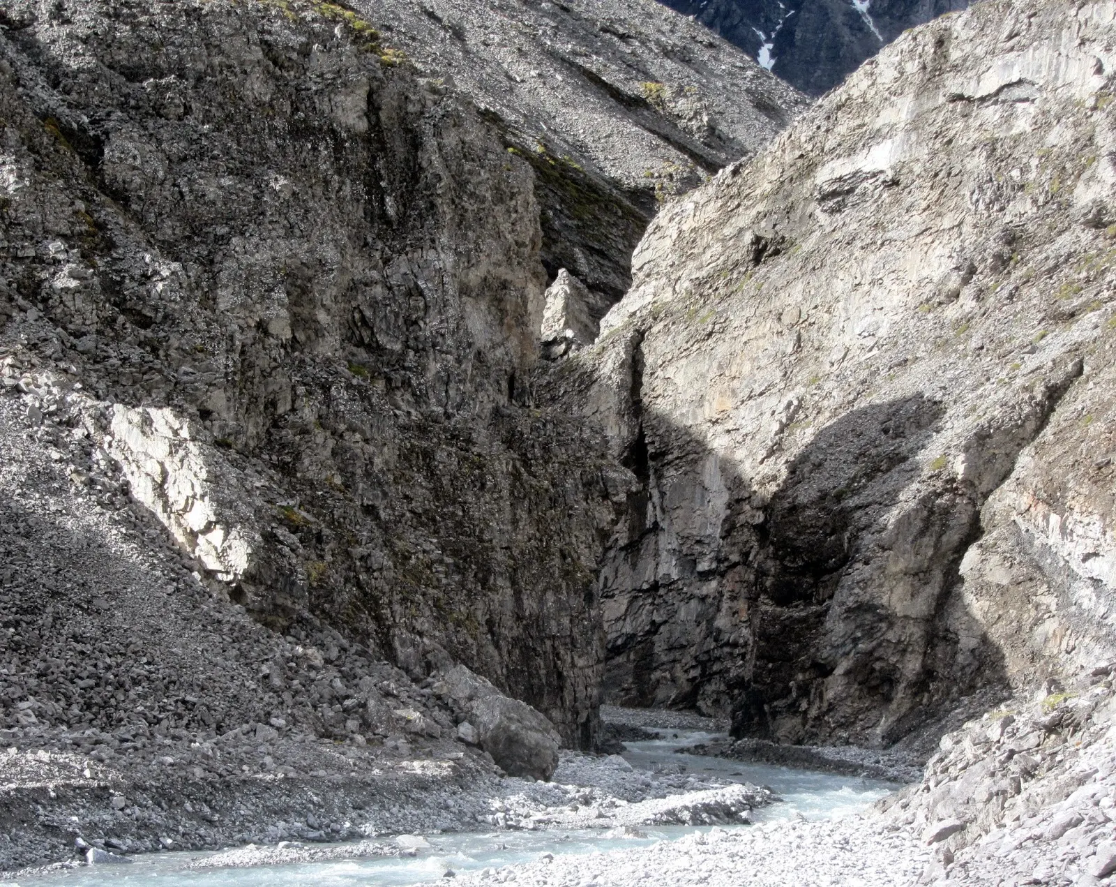
Milliseconds later, perhaps, my left hand, scrambling frenetically, found a grip on something that stayed in place, and I could ease around the corner and get onto a ledge with some solid footing. After about a minute I was down on a safe gravel bar. When the tension left my body I could feel the sobs breaking through the armor and I sat down on my pack and cried for a full minute.


The creek I would be following over to another drainage tomorrow, ran in a fairly deep ravine. But parallel to this creek, on the other side of the ridge that made up one of the ravine wall, another creek ran for a long stretch. The two creeks joined not far from my tent. The rest of the landscape was on par with this, a very varied mixture of hills and gullies and small brooks. Very difficult to describe, but lovely. I took a number of photos trying to capture this wonderful haven, but none of them could in any way match the reality.


By Jörgen Johansson

The chilly
wind also motivated me to walk briskly, hiking poles clattering on the rocky
floor of this gaping mouth into the mountains. It took me about an hour to
reach the place where the one creek was born from three different water sources,
coming down their separate canyons to a wide, stony expanse surrounded by high
peaks. It was quite a place, like a mountain cathedral.
After a
brief rest on the cathedral floor, drinking a cup of cold water and eating the
usual snacks, I took to my road. This was a fairly small brook, foot deep and four-five
meters across, that poured out of a much more impressive ravine. Following this
upstream for some four kilometers would take me to pass 7520.


It started
out well enough. I could shift from one gravel bar to another when steep cliffs
bordered the stream. When the walls closed in from both sides I could walk in
the water. But it soon got a bit worse. Or a lot worse.
In places
the stream got so compressed and narrow, with fast moving and deep water, that
I could not walk in it. I was then forced to climb the least steep of the canyon
walls briefly, to reach the other side of this particular bottle-neck, where
the ravine and stream once more widened and offered gravel bars for walking.
Some of
these climbs where not very high and not that technically difficult, even with
a 15 kilo pack. However, now and then there were passages that were less than
pleasant. Every time this happened my hope was that ”this was the last
bottleneck”. After having managed four or five such tricky climbs I also was
becoming less and less attracted with turning back and having to do those
passages all over.

As I made my way upstream in this gorge, things did not get any better. The short climbs got longer, the unpleasant passages were shifting into being downright scary. I was becoming seriously worried that I would injure myself. One mistake, one slip, could have dire consequences.
Getting
close to the top of the ravine, where I hoped I would see the pass, there was a
sort of rock corner I had to get around. The bottom of the ravine with the
creek was some ten sheer meters below. A fall here would be serious business.
I am no
climber and climbing with a big pack and walking poles is not something that
makes this kind of scrambling any easier. I did however feel that poles in many
cases where actually more help than hinder, but everything would have been a
lot easier with some better rock to hold on to.
The rock
here was incredibly crumbly. Almost every rocky outcrop tended to come loose in
my hand. Rounding this rock corner, I had the sickening experience of a
handhold like that coming loose. I could feel myself, in some peculiar slow
motion way, pulled by my pack, begin to topple away from the rock face.

Milliseconds later, perhaps, my left hand, scrambling frenetically, found a grip on something that stayed in place, and I could ease around the corner and get onto a ledge with some solid footing. After about a minute I was down on a safe gravel bar. When the tension left my body I could feel the sobs breaking through the armor and I sat down on my pack and cried for a full minute.
Now, going
back was not, in my mind, an option and not long after I came to a steep slope
covered with snow. Could this be my pass? I was still not familiar with exactly
how the map portrayed the terrain in these steep surroundings. Coming up the
gorge I had spent a lot of time going very short distances. Somewhere along the
line I had lost my dead reckoning. I was not certain where I was, with my less
than detailed 250 K map.

I zigzaged
up the snow covered incline, kicking steps in the slushy snow with my Salomons,
wondering if this was the end of my climb, if I would look down on the other side of the pass from
the top. Another
slight incline met me after the first one and I trudged up that one as well,
still hoping. What I finally saw was not really the top of the pass, but rather
the bottom.
Ahead and
around me a wide snow patched rock basin, met my eyes. A big glacial cirque
would be my guess, where a number of football fields would have fitted. Except
for where I was standing, there were no exits, just a huge half circle of
jagged peaks connected by high ridges.

My eyes
found the lowest spot on the sky line, right next to a prominent peak that
looked like it would be my old friend 7520. The lowest spot would of course be
the pass I was looking for. From the top of that pass a long strip of last winter’s
snow hung, like a white tie down a fat man’s chest and bulging belly. It looked
steep, really steep. Really, really steep.
From where
I was standing it would be approximately a kilometer of mixed rock and snow
fields, to the bottom of this white tie of a stairway to my pass.
A good time
for lunch.
I rolled
out my pad, pulled on my puffy layer hoody and sat down. While waiting for the
water to boil I studied the steep climb along the seemingly vertical snow
patch. Maybe it was not quite as high and steep as had been my first
impression. And other people had presumably used it, people on more or less the
same route as myself. Buck Nelson maybe, probably not Andrew Skurka who had
been on a slightly more northerly route through this part of the Brooks.
Well, if it
was an established pass it was supposedly negotiable and if so, why not by me.
It took me
about an hour after lunch to reach the rocky slope below my snowy ladder. A
couple of times along the way I had turned my head at cracking sounds and with
my eyes had followed rocks thawing away from the steep mountain sides around me
and bouncing down the precipices until they found a resting place at some snow
patch on the cirque floor.
My biggest
help, slowly zigzagging up the 10 meter wide snow patch, was the consistency of
the snow. It was soft and wet enough for me to be able to kick reliable footholds,
but solid enough to support my body weight and pack weight while arduously shifting
from one foot to another.

The pace I
soon established was some 30 seconds of zigging with 30 seconds of rest
followed by another 30 seconds of zagging. During the stops I looked at the
view. It was no doubt stupendous, but I did not enjoy it much. This patch
of snow that clung as my lifeline to the incline was steep. Really steep.
Really, really steep.
It felt
like 60 degrees, which probably was an exaggeration. Maybe 40-45 degrees. I
made a halfhearted attempt to judge the steepness with my two poles, but my
heart was not in it. It was purely of academical interest, now that I was in
the middle of the thing.
There was
no way I would have dared climbing the rocky rubble bordering my white ladder.
Without the snow it would have been no go. Looking down it was obvious that a
fall in this place would be very difficult or impossible to break, if I started
tumbling with my big pack on. It seemed a certainty that I would be ground to
pieces when I started hitting the rock slope below the snow field at high speed.
There was
only one way of getting out of this and that was the hiker’s usual mantra, to
keep putting one foot before the other for as long as it took. In its upper
part the drift was compressed into a narrow waist by two rocky outcrops
squeezing from both sides. The one to the left was perpendicular, the one to
the right more promising, less steep than the snow I was stomping my way up in
anyway.
I felt a
certain sense of elation when I could put my hands and feet on the rocky
outcrop to the right and get away from the awful steepness of the snow strip.
My elation did not last long. Another area of crumbly, crap rock met me and it only
took half a minute to realize that this was less safe and reliable than the
snow. Carefully and slowly I retreated to the now very narrow waist of snow and
kept on making zigs and zags, each leg of those only a couple of meters.
On another
level, my brain had to build a sort of expectation barrier. This had to do with
what could be expected on the other side of the pass. I had to avoid creating in
my mind an image of a gentle slope that would let me have a nice
walk-in-the-park descent, the sun joyously sparkling on the snow fields that I
would happily skate down.
I simply
needed to be prepared that the other side of the pass could be just as steep
and dangerous as this one. In fact, this was a more likely scenario. The map,
with its lack of detail, did not offer much information on this. The worst case
scenario would of course be that it was just as steep or even steeper, but
without any handy snow fields to help me stay on the rock wall. So steep that I
would not be able to get down. So steep that I would have to go back the way I
had come.
If I expected
too much, was too optimistic, the disappointment might damage or shatter the
thin layer of absolute focus that was holding me up. The absolute concentration
that I needed, in order not to make one single misstep, must not be dented if I
could in any way prevent it.
Soon the
rock out crop on the right petered out and let the narrow waist line of snow expand
to a wider patch. This also was the end of the steepest part of the incline,
instead I had a steep hill stretching some 50 meters ahead, where I could walk,
albeit slowly, in a straight line to what I hoped to be the top of the pass.

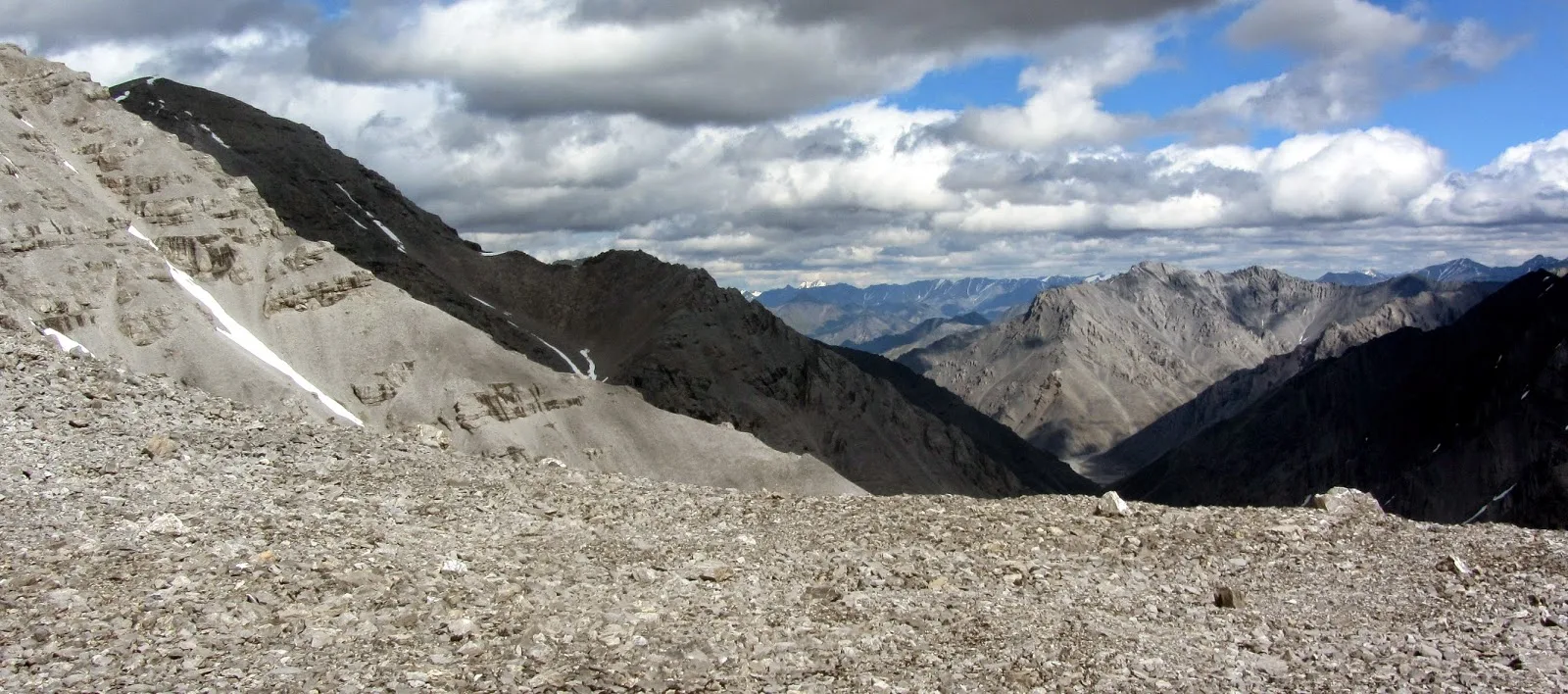
It was the
top of the pass. An almost flat, rock strewn area of some 50 meters across and
gently curving upwards several hundred meters to the sides. The sun was
shining. I looked back the way I had come and could see marvelous peak after marvelous
peak rolling towards the eastern horizon. Man, this was country!

I took a
couple of photos of this view, perhaps subconsciously postponing the
exploration of the other side of the pass. Then I walked across and looked down
on the other side.
The view in
this direction was also great. And it looked better than I had dared hope. Not that
steep compared to what I had just experienced. I had some water and snacks with
this wilderness world that is the Brooks Range at my feet, before starting
down.
It was in
fact a gentle slope that did let me have a nice walk-in-the-park descent, the
sun joyously sparkling on the snow fields that I happily skated down. It seemed
too good to be true. And in fact it was.

My goal was
the Canning River, which I would follow for a day or two upstream, before
cutting across to its tributary the Marsh Fork of the Canning River, where my
food supplies for the next couple of weeks awaited me.
The canyon
on this side of the pass, following the ever-growing melt water creek down
stream, was a lot easier to negotiate than its neighbor on the other side had
been. This one also had cut its share of deep ravines in places as well, but
finding a good route to safely circumvent the worst bottle necks was made
easier by coming from high ground and having a better view of what was below
than what had been the case coming up the creek on the other side.
After a
couple of hours of hiking, and a nice cup of coffee in the sunshine, the canyon
ended and the creek continued into a sizable valley with a river running down
the middle of it. Just like the Canning River would. However, two things were
wrong: This river had appeared much too quickly and it was running in the wrong
direction.
Time to
take stock. Also time to take a more than cursory look at the map and also to haul
out the compass for the first time this day. Following ravines, like I had been
doing, I did not feel I needed the compass much. Big mistake.

Perhaps the
adrenaline rushing through my system this day had managed to rattle my brain
out of its usual comatose state, because it did only take me a couple of
minutes to figure out what must have happened.
Reading the
map very carefully indeed, as I should have been doing all along, I could see
that the big cirque where I had started my ascent up the steep snow ladder was
the home of, not one, but two passes.
The pass I
had picked was to the far right in the cirque, which fitted with a casual look
at the map. The pass should lead north, which it also seemed to do. I should
have checked this direction with my compass. Because what I had done was take
the pass going the south from the rock basin. I had seen no other pass and
erringly thought “I follow the creek upstream until it ends and the lowest spot
on the ridgeline will be the pass”.
What I was
looking at was not the Canning River but a tributary of Red Sheep Creek. So
what I had done was risking my life in order to achieve nothing really, remain
on the south side of the Continental Divide and I had done so by crossing a
pass that no sane person would bother to climb simply because it did not get
you anywhere.

A quick
look at the maps covering the area between where I was and the March Fork cache,
did however cheer me up a bit. This was confirmed when I had descended to the
sizable tributary of Red Sheep Creek and set up camp. Taking my time over the
maps in camp it seemed I could reach the Marsh Fork fairly easily by following the
creek outside my tent down to Red Sheep Creek, follow that for some distance
and then cross over to Cane Creek and then another crossing to a drainage that
would lead me to the re-supply cache in three days or so.
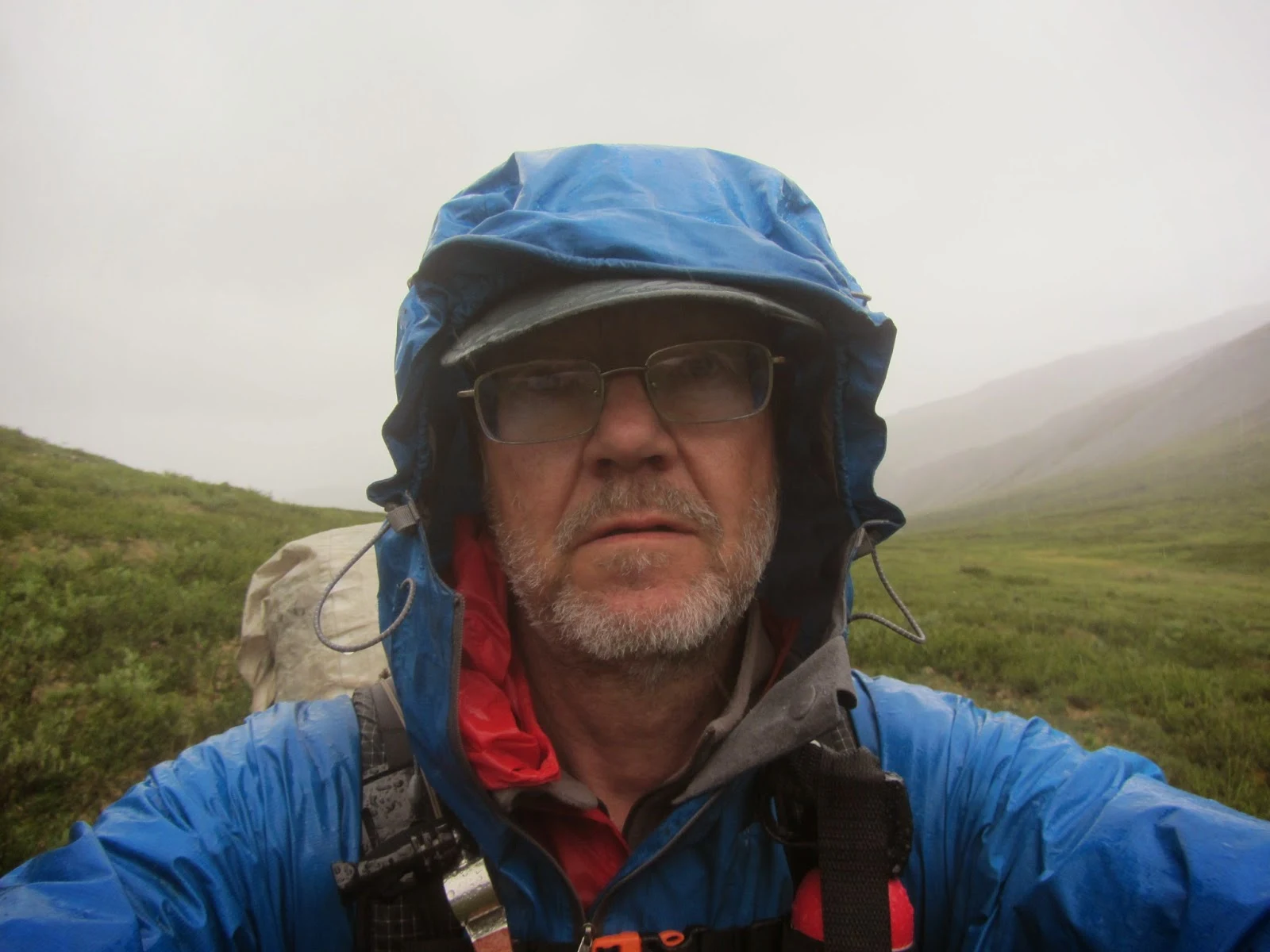
It rained
all night and almost all next day, but I made good time along game trails down
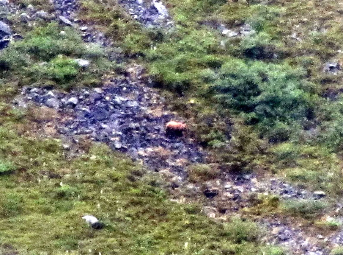
to Red Sheep Creek. The most eventful thing happening this day was triggered by
a movement half-way up the other side of the valley. My cheap binoculars were
soaked and misted over, but the camera proved that it was a grizzly.

It slowly
made its way along the slope, at least 500 meters from me, looking for
something edible it seemed. I snapped a couple of photos and moved on in the
rain. It was decidedly chilly, some 7-8 C and difficult to keep warm without
moving at a brisk pace.

This would turn out to be the only bear
encounter on my walk through the ANWR. It has been said: This is not the
Serengeti. It is a very lean part of the world.
The chilly
rain kept me company all day. As before, the rain had soaked through underneath
my waist belt and my merino shorts were all wet and draining me of body heat.
The best proof that circumstances were miserable this day is that I decided to
skip afternoon coffee. I only took a short snack break, sitting on my pack in
the rain, and decided that I would set up camp around 6 pm, an hour or more
earlier than usual. This would get me into my shelter, into dry clothing and into
my sleeping bag. Nothing seemed more attractive right then.

Well, you
never know what happens. Around 6 pm the rain stopped, the clouds began to lift
and I found myself in the most magical of valleys. I pitched my tent and spread
wet clothing out to dry. Suddenly the world was a friendly place. I looked
forward to eating my eternal noodles and beef stick sausage under the sky for a
change, but just when I stuck my spoon down in the steaming bowl it began
raining. I rushed to get everything spread out to dry before it got soaked
anew.

When this
shower had passed I took a walk around camp. The surroundings were not that
spectacular, the mountains not that high and pinnacled around me. It was more
like a whiff of Scotland, with a lot of green shades all over. What made this
into Camp Magic was rather this sort of coziness after several days of high
mountain harshness combined with some strange geology.

The creek I would be following over to another drainage tomorrow, ran in a fairly deep ravine. But parallel to this creek, on the other side of the ridge that made up one of the ravine wall, another creek ran for a long stretch. The two creeks joined not far from my tent. The rest of the landscape was on par with this, a very varied mixture of hills and gullies and small brooks. Very difficult to describe, but lovely. I took a number of photos trying to capture this wonderful haven, but none of them could in any way match the reality.

The next
day I topped out on a rise, exciting my magic valley and seeing Cane Creek
spread out below me. Straight across the valley I saw the next side creek I
would be following upstream to another pass that the map did paint in much more
forgiving colors than it had the hair-raising ascent of pass 7520. A chilly
wind was blowing, with promises of rain.

I descended
and then crossed Cane Creek easily enough and started up this new creek with no
name. It was very similar to the creek leading up to pass 7520, a fairly narrow
and shallow creek that was easy to ford and easy to walk in most of the time
when the side walls closed in. In places there were snow bridges I could walk
on for short distances. But again, the side walls kept closing in and kept
getting higher and steeper.
After a
while I came to a gash in the rock where the creek, now only a meter wide and
with noticeable power, thrust over a rocky threshold into a pool that promised
to be more than waist deep. Not an appetizing prospect to swim-climb this
forceful opponent, although it looked doable if I stripped completely and only
donned my rain gear. I looked around for options.
The wall on
my right looked climbable up to a seeming ledge, some five meters up. I could
see the narrow gash around the creek widening into gravel bars only a short
distance upstream. I started climbing.
The seeming
ledge did not turn out to be something that would let me negotiate my way past
the watery gash. However, the slightly curving incline above it looked
climbable up to another seeming ledge that hopefully would be more walkable.

If you put
a frog into warm water, it will jump out. But if you put the same frog in cold
water and gradually increase the temperature to warm, it will it adjust its own
body temperature to the surroundings until it dies from overheating.
To cut this
simile and a long story short, after three-four pretty difficult scrambles to the
same number of ‘seeming’ ledges that promised passage, but did not deliver, I
was what is endearingly called, up the creek without a paddle. It sounds more
fun than it is.
Some hail
travelling on the biting wind found me on a steep slope a couple of hundred
meters above the creek, which was dotted here and there with snow-bridges. The
way ahead looked chilling, and that had less to do with the weather than you
would expect.

The slope
was pretty steep, though nothing like pass 7520, in places with grassy strips
and some reasonably walkable drifts of gravel and small rocks. But most of what
I could see of the slope ahead consisted of large areas of slick-rock. From a
steepness point of view they looked sort of walkable with rubber soles giving a
good grip. I had that. The problem was that these big and small slick-rock
areas were liberally sprinkled with bigger and smaller rocks.
These rocks
would act as ball-bearings if I tried to walk on them, rolling under my feet.
And if I fell on a slope like that there was no way I would be able to arrest my
fall. I would tumble head over heels with a rapidly increasing speed down the
entire slope and end up a reddish mess in the creek at the bottom of the
ravine.
Yet, I had
to move ahead, angling down towards the creek, even if this would, sooner or
later, lead me to a complete dead-end. That is how I reasoned, anyway. Maybe
this was all wrong. But I do not like to go back. I’m too lazy I guess, to let
all the work behind getting this far be for nothing. Another weakness I have is
that I’m really poor at quitting. So I started delicately to make my way across
the slope ahead.

Before I
started I took a photo looking upstream and another looking back towards Cane
Creek and the slope I had clambered up. These turned out to be the last photos
of my trek.
By now I
was past the bottleneck along the creek that had put my up this incline, so I
was looking for a way down, but for now I had to move parallel to the creek,
looking for spots and strips that looked like providing traction, avoiding the rock
studded slick-rock death traps.
I slowly
made my way, in some places easing myself down on my butt on smaller areas of
gravel studded rock, feeling the seat of my rain pants shredding in the
process. I had no real sense of time passing, just concentrated, scared and
praying that this would end well.
After a
while a dry gulch running down the mountainside, all the way down to the creek
and perpendicular to it, blocked my progress. It had more or less vertical
walls, some two-three meters high, but the bottom of this 10-20 meters wide
melt water gutter consisted of fist and head sized rocks that promised a
reliable, if not stable, footing. The problem was getting down there.
I made my
way downhill along the edge of the gulch until I found a likely ramp-like notch
leading down the wall. I eased my way down. I had to use every bit of traction possible
to keep myself from beginning to slide. Finally I realized that I had to take
off my pack and lower it ahead of me, down the ramp. This would allow me to
climb down the last meter or two onto the rocky gully floor.
I got my
pack off without trouble and started easing it down, one-handed, along the
steep ramp. If it would slide gently on this flat rock surface a meter or so,
it would hit the rock and gravel mixture of the gully floor and stop. I let go
of my grip and watched the white HMG pack start sliding.
After about
one second it stopped sliding and rolled over once. Then another roll, and it
left the slick rock ramp. It all happened very fast now. The pack rolled over
again on the rock and gravel, and now it was really beginning to travel and the
steep slope quickly gave it a tremendous speed.
I saw it gathering
speed; now ten meters away, now twenty. Before it disappeared from sight I saw
items attached to the outside of the big bag start to scatter wildly. Then it
was gone from sight.
The climb
to the bottom of the gully without the pack was just as easy as it had looked,
and the rock and gravel surface as easy to walk on as well. I went down to
where the pack had gone out of my sight and collected the belt pouch that
contained my camera in a hard case, plus maps and compass.
Then I
started down the slope, which had a gentle curve that obscured the creek at the
bottom of the ravine from view. Where and how I would find my pack, I wondered.
Would it be smashed to pieces entirely, shredded by high speed and sharp rocks?
Would it be resting in the creek? Would it have been flushed downstream by the
creek? Perhaps jammed under a snow bridge where I would be forced to crawl into
some icy hell-hole to retrieve it, or maybe would not even find it.
Wow, this is powerful stuff, I have never been in the situation your were in and don't know how I would handle it. It is evident your determination coupled with considerable experience got you through what was clearly a challenging (dangerous) situation. Well done, I imagine this chapter was also hard to write with the memories of the challenges and how you felt as you revisited this part of the trip. Looking forward to a less stressful next chapter.
ReplyDeleteRoger, I think these experiences have contributed to the fact that it has taken me a while to 'get into the mood' to write about my trip. We'll see what happens next ;-)
ReplyDeleteWow! That gives me the shakes just reading about it!
ReplyDeleteRobin. Sounds like I succeeded in my communication of what gave me the shakes experiencing it. Of course, for a mountaineering type of person the whole thing might have been a breeze, but being a walker I can only relay how I felt.
ReplyDeleteBreathtaking...and kinda scary. Can' t wait to hear the next chapter :o)
ReplyDeleteThanks Terje. I'm working on the next chapter. To bad I have to do some real work as well ;-)
ReplyDelete