The rain
had started again by mid-afternoon, when my descent ended at the Sheenjek river
bed. Things did not look too bad. There was no lake, just a wide valley almost
filled with gravel bars intermingled with some running water.


By Jörgen Johansson

The river was
extensively braided, which always simplifies river crossings according to the
divide-and-conquer rule. You cross one segment and then potter around until you
find another potentially fordable stretch of water and so forth. The main
channel did look impressive but not impossible. No use trying that one on until
I had rested a bit and fueled up. I stopped for coffee.
I halted in
the dripping willows a couple of hundred meters from the Sheenjek channels. It
was chilly and rained heavily. The
arms-length piece of thin nylon cord tied to the top loop of my Trailstar I
tied as high as I could reach in a willow. The other cords, normally used for
pegging, I tied a bit haphazardly among lower branches in a rough circle.
The result
was a big enough area for me to comfortably move in and sit down under, out of
the rain. I pulled off my rain jacket and pants and put on some warm clothing.
Pile socks for my feet was always nice. My puffy layer was an AsTucas Sestral
synthetic hoody, keeping torso and head from losing heat, thereby keeping my
entire body warm.
Coffee breaks
was usually taken around 4 pm and consisted of (yes) coffee and some 15 centimeters
of beef stick sausage rolled in a soft tortilla. To this I added the snacks I
always munched at my hourly breaks; some chocolate, raisins and nuts. This always
kept me going nicely until my evening noodles around 8 pm. And if you wonder
about this obsession with coffee, Sweden has one of the highest per capita
consumptions in the world, second only to Finland, I have heard. It is a
ritual, like the Brits and their tea.

During the
time it took to get the coffee and sundry under my belt, the rain had eased off
and then stopped completely. I put the Trailstar in its stuff-bag attached to
the outside of my backpack. I always try to avoid putting my shelter (or rain
gear) into the main compartment of my pack. I find it a lot easier to get at these
things when I need them and it also and keeps the inside of the pack drier,
should they be wet. I had made a couple of holes in the bottom of the Trailstar
stuff sack with a soldering iron for drainage and attached it to the outside of
my big HMG 4400 Porter Pack.
The
Sheenjek turned out to be easy to ford right where I had reached it. The main
channel was an ’80-percenter’. I went slowly and carefully, only moving one of
my four supports (feet and hiking poles) at the time.
The gravel
bars and willows on the west bank turned out to be a lot more of a hassle than
the ford. There was only a fairly narrow stretch of dry land between the last
channel and a steep bank up towards the mountain slope. This stretch of land
was heavily willowed, if that is a word, and game trails were pretty
non-existent.
I soon put
on my waterproof RAB eVent Smock to avoid getting soaked from the rain-heavy
foliage. After a while I got tired of this sloshing and tangling and decided it
might be worth the climb up the graveled bank to check out the terrain sloping
up towards the steep mountain side. Maybe things would roll easier there.
They certainly
did. I came up on a huge, almost entirely flat expanse gently sloping towards
the river and the steep bank I had just climbed. This big area was covered with
a vegetation of grass, moss and lichens not rougher than on a golf course
fairway. It was almost too easy to walk there, but I was not complaining.

After a
while I saw some strange-looking rocks in the distance. They turned out to be barrels
placed beside what was obviously what the bush-pilots sportingly call an
‘airstrip’. Up in the Brooks this signifies a place big and flat enough to land
a small plane on and also with a bit of luck, take off from. These barrels I
was looking at were somebody’s cache (#9 it said). My own cache was still about
a week away, on the Marsh Fork of the Canning.

I felt
strong and contented while hiking the last hours of the day on the gentle slope
spreading between the Sheenjek River and the Double Mountain rock wall. After a
couple of hours I reached some stunted evergreens, the first I had seen so far.
This was dry country, but a sizable snow field uphill melted its way down to
the Sheenjek in a nice trickle that would suffice for my needs. This would be
Camp Sheenjek I decided, as I pitched my soaking tent, letting it dry out in
the stiffening breeze while making supper.
In the
morning I strangely enough, considering how good I had felt by the end of the
day before, was a bit listless and low on get-up-and-go. I slept in and loafed
around in camp, taking my time until I finally moved off around 9 am.
I turned
out to be a glorious day.

Hiking down
along the Sheenjek I could see the river rapidly putting on muscle. Soon there
was only a limited number of channels that did not invite fording. There was
also plenty of aufeis, as I neared the southern corner of Double Mountain.
“Aufeis is German for “ice-on-top”,it is
a sheet-like mass of layered ice that forms from successive flows of ground
water during freezing temperatures” to quote Wikipedia.

There had
been aufeis along the Kongakut in places as well and I had sometimes walked on
it. Hiking on the ice can be an advantage, since it is flat and you can move in
a straight line towards your goal. On the other hand I had found it sometimes
dangerously slippery when the soft snow on top gave way to ice with meltwater
on it. Getting on an off the aufeis could also be a problem and sometimes felt
risky, with slanting and slippery edges that also often had an overhang, from
it having melted more close the ground than on top.
The aufeis
on the Sheenjek was 3-4 meters thick and meltwater was running off it in
rapidly eroding gullies of ice. Not inviting and besides, not going in the
direction I was. The sun was shining softly on the white ice and the blue water,
which were framed by the stunted but confident evergreens. If this was not
Alaska, then nothing was.

Most of the
morning I hiked through the sparsely forested strip of land that had taken over
from the arctic steppe of yesterday afternoon. It was an ever-narrowing piece
of real estate, squeezed between the Sheenjek and Double Mountain.

I enjoyed
the smell of the dry moors, with grass, lichen and heather crumbling beneath my
feet in the sun. The moor parts were interspersed with soggier passages and the
scenery down the river was magnificent.
However, approaching lunch time I had
realized that travelling was easier on the gravel bars next to the flowing
river. There were also less mosquitoes down there, so lunch was taken right by
the gently flowing water of a sturdy tentacle reaching out from the main
channel of the Sheenjek.
Around 3 pm
I rounded the southern tip of Double Mountain and started going upstream a
tributary of the Sheenjek that would take me to a seemingly gentle passage from
this drainage over to the East Fork of the Chandalar River.
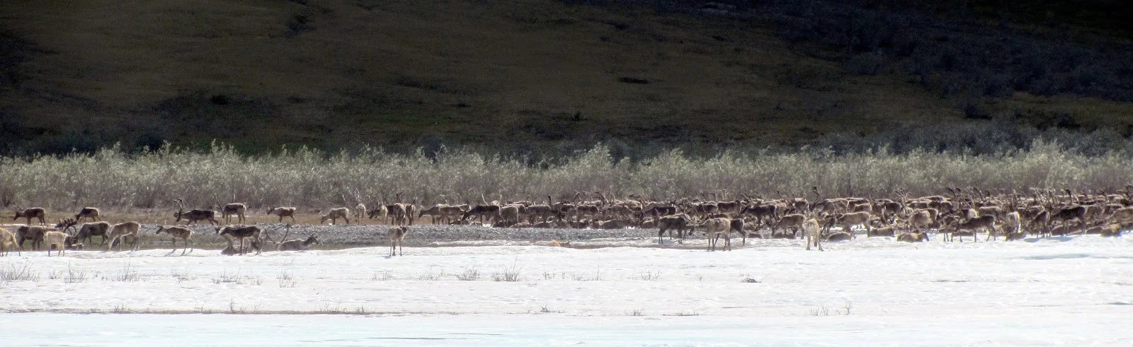
After about
another hour of hiking I saw movement on the opposite bank of the sizable
tributary, some 300-400 meters away. In fact, it looked like the whole river
bank was moving. Caribou.

When I had
taken stock I could see that it was a herd the size of a 1000 animals or so,
spread out along the river bank across from where I was. Hard to find a better
reason for a cup of coffee and the usual condiments than right here.

I pulled
off my shirt and let it dry in the sunshine, while firing up my stove. Then I
took my time over coffee, looking at the caribou through my binoculars and
taking a number of photos, enjoying the sunshine and the snacks.
The caribou
where not moving much, just milling about, eating a bit, but mostly trying to
use snow patches, movement and shuddering to ease the pain from the harassment
of millions of insects. I had been told that a caribou calf could lose one
liter of blood per week to mosquitoes.

These poor mammals
are also pestered by flies laying eggs underneath their skin. Eggs that hatch
into larvae that dig their way into the caribou or out of the caribou,
depending on what species of fly we are talking about. So any place that could
offer some cooling and comfort is greatly treasured by these migrants of the
north.
The warm
weather stayed with me going up the valley. It was easy going and I made good
time. When it began to be time to look for a campsite I spotted a bunch of
sizable cottonwood, the biggest trees I was to see during my hike. I pitched my tent among them, the plan being
to get some shade for the Trailstar from the trees, but the sky soon became
overcast and the wind picked up during the evening, making that unnecessary.

The
crossing to the East Fork of the Chandalar was via a gentle slope. Everything
was so similar to the crossing from the Kongakut to the Sheenjek that they have
become a bit mixed up in my memory. Checking my notes and photos, though, helps
me to tell them apart.
It did not
rain as I reached the East Fork of the Chandalar and the fording was so easy
that I had coffee afterwards instead of before. I started following the river
downstream with a steep mountain to my right. I would follow it south and then
head northwest along a tributary coming down when the nameless mountain ended.
All very similar to the Sheenjek.
Not so similar
was that just a couple of minutes after my coffee break I saw something out of
the corner of my eye that made me turn my head. Two hikers were coming along
upstream on the gravel bar about 100 meters away.
The hikers
turned out to be Don and Erin, a fit couple of about 40 years of age. They had
been hiking upstream along the East Fork for a week and were headed in the
direction from which I came, the Sheenjek where they would be picked up at the
airstrip. Don was sporting a chunky piece of wood in one hand, hiking pole in
the other, having lost one pole during a difficult ford.

Pretty soon
I was on my way again, hoping for a nice, speed-hiking shelf above the river. I
had climbed higher than intended before I realized this would not materialize,
like it had on the Sheenjek. Before I descended down to the gravel bars I took
some photos. With the view from this ridge down the river it was worth the
unnecessary climb.
Camp that
night was right were the mountain gave way to the tributary that I was going to
follow towards Guilbeau Pass the following morning. The area was open, but I
camped between some willows close to the stream according to my rule of picking
a reasonably protected camp spot if this was possible. The mosquitoes were
ferocious on this slightly overcast evening, so I soon retreated into the tent.

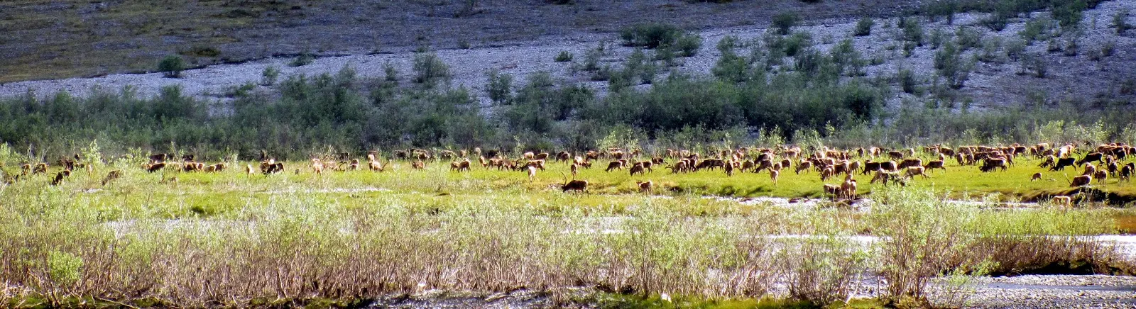
Don and
Erin had said that I might encounter a herd of some 20 000 caribou coming
down through Guilbeau Pass from the North Slope tundra. That would really have been
something to see. Obviously a part of the Porcupine herd had been reported
coming south from the calving lands. Unfortunately, I never met this herd. It
is likely that the herd I had seen on the Sheenjek tributary the day before
instead had been the tail end of said herd going down the Sheenjek.
From looking
at the map, Guilbeau Pass looked a lot less steep than many other passes along
my planned route across the ANWR. It felt like it could be a nice warm-up for the
higher and steeper passes on my agenda.Not so.
Guilbeau Pass turned out to be a lot trickier than I had expected. A whisper of
warning of things to come.

Although
not that steep in elevation difference between the two sides of the pass,
navigating it turned out to be some complicated route finding with my large
scale map. The pass had a number of small side creeks running at the bottom of
some very deep and very steep gullies. Keeping the direction without being
sidetracked demanded some attention, finding a route according to that, which
did not involve steep gorges or very steep talus slopes hanging on to the
surrounding peaks was even trickier.

Some of the
scarily steep shale scree slopes still showed that the caribou had travelled
them, hundreds of vertical meters above the icy creeks. After a while I started
suspecting that if the caribou could go down or follow certain slopes, so could
I. I did my best to stay away from the steepest areas, but was beginning to develop
a feeling for which kind of scree slopes were walkable and which weren’t.
Still, I blundered while passing the lake at the top of the pass, did not read
the map carefully enough and had to descend an unnecessary steep slope.
Entering
the pass, the weather had been getting harsher as well and here on the north
side of the continental divide it was overcast and a bit chilly. The walking
was easy though, and I could keep a good pace for the rest of the day, on my
way to the Hulahula River.

This river
I would only say a brief ‘hello’ to, before turning south towards a pass that I
had some doubts about. Pass 7520. The doubts consisted of it not being marked
on my map as a pass I would cross. Nor was any other likely crossing of the
mountains in the area. I had relied on my GPS and its waypoints here, but on
the 250 K map this pass looked to be the only one available in the general
area. And my own memory was pretty blank when it came to this particular area.
The
Hulahula River reputedly got its name from Hawaiian whalers some hundred years
ago. Maybe they thought that the river seen meandering across the tundra far
north, by the Arctid Ocean, reminded them of dancing delights in a warmer
world.

I did not
see much of the Hulahula River, but my sympathies were all for a warmer world,
not to mention dancing delights. It had rained all night, heavily, and I had my
first day of persistent rain for almost the entire time that I was hiking. The
morning was worst, with a chilling wind that made me happy to have my homemade
Cuben mitts on top of my fleece gloves.
I came from
the south along a tributary, and rounded a promontory where it joined another
sizable creek, to be christened the Hulahula, at least on my map. I went back
towards the south, upstream along this second tributary, which I would follow
to its birthplace and pass 7520.
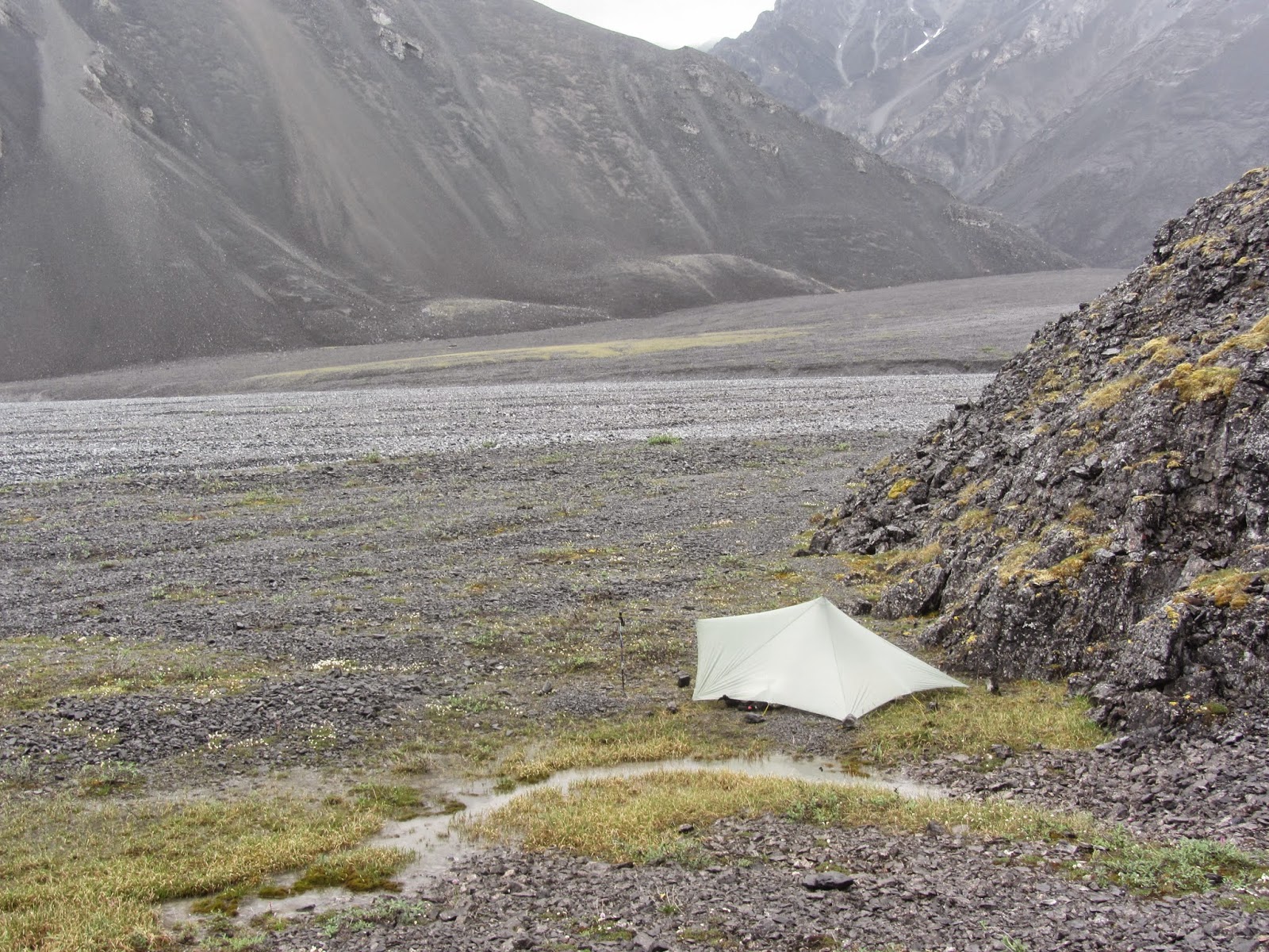
Having rounded
the promontory I hiked a kilometer or two, I then pitched the Trailstar in the
rain and moved in without setting up the inner tent. I was really happy to put
on dry long johns and warm socks and then add the Sestral to maintain my core
temperature as close to 37 Centigrade as possible.

The rain had soaked through
both rain jacket and rain pants under the packs waist belt. It had presumably
been pressed through the fabric layers and my pants and merino shorts were
pretty wet.
Warming
myself here, I had my lunch consisting of a double portion freeze-dried. Then I
stretched out and rested awhile. After an hour I was back in the rain.
A soft hand
on the tap turned this rain into a drizzle during the afternoon and an hour before
I started looking for a camp site it had stopped completely. The world around
me, however, was still draped in rain heavy clouds, swirling around some
spectacular mountain scenery. There was a feeling of, if not doom, at least
gloom.
This was
added to by the fact that I had left almost all kinds of vegetation behind,
steadily gaining elevation in this wide but barren valley that dwarfed the
sizable creek running down its midst.
The wind
was whipping at my face, quite strong and quite cold. This would be an
excellent night for a protected campsite, no telling if the wind might pick up more
during the night. My hopes for finding such a spot were not high though, the valley
was as flat as a pool table but a lot colder and not really green.
However, to
my surprise, a major narrowing of the valley occurred, due to a sizable ridge pushing
out at right angles from the steep slope on my right. Right at the base of this
ridge I could pitch my tent well out of the wind.
I had in
fact hoped to hike another couple of kilometers upstream before the day was
through, to where this very creek was created from three separate streams
coming down from three separate canyons. One of these streams I was to follow up
to pass 7520. The pass did not have any name, but was situated close to a peak
that was unnamed, but had its elevation in feet printed on the map.
Pass 7520
had been an issue for a number of days. Since I was uncertain if this really
was the pass I had planned to cross but was unable to be judge this from my
map, I had sent a number of text messages to my wife in order to, if possible,
get things clarified. The reason for the text messages was that I had noticed
only after a couple of days of hiking that the battery indicator on the sat
phone was down to 50 percent.

If this was
correct the thing was eating batteries, and they had to last until I reached
the spare batteries at the cache on the Marsh Fork of the Canning River. Also,
if I needed the cell phone in an emergency, there had to be enough juice left
in it for a reasonable amount of voice-communication.
So we
started sending text messages to each other, but after having received no
replies to my own texts for a number of days, I had called my wife and found
out that she was receiving but that my sat phone, for some reason, did not
receive her answering texts. After this we decided that she would call me after
having read my daily text messages. In order to save my batteries I would not
answer, but the phone signal itself would communicate: Message received.
Now I had
received a message confirming that pass 7520 seemed to be the right one. This
would later turn out to be wrong.
When I
started out towards the pass the following morning, going to where the three
streams would meet to create the one I was following, it was still overcast,
with grey clouds hanging low. I took a photo of the somber valley slowly closing
in from both sides. It could have been leading into Mordor.

Mordor mentioned! ;) I'm going for the a-word and say this series of reports is awesome. I've enjoyed them a lot and am looking forward for the next parts. Thanks for sharing!
ReplyDeleteThanks, Korpi for your appreciation. Sharing is re-living so it is also very rewarding for me to write about my hike, now that I have some perspective on it.
ReplyDeleteCoffee, is the word, it seems that Coffee permeates this post along with isolation, rain and persistence. I wondered what coffee you use on a trip such as this. I am already aware of your cooking routine so I assume you cook breakfast, lunch afternoon coffee and dinner on a trip such as this. The sight of the Caribou, and bumping into a couple of hikers must have been special. So you have been Mordor and survived, well done. looking forward to the report of the unnamed pass, given that the pass was the wrong one. But the good news is you survived.
ReplyDeleteRoger, Once there was GORP, now we have CIRP (coffee, isolation, rain, persistence), thank you for that one.
ReplyDeleteYes, you have my routines pegged down. What I use for coffee is just plain instant coffee from some well known brand, preferably Fair Trade and Ecological. I brought one such package from Sweden (so as not to run into some weird, outlandish flavor) an it lasted the trek.
How do you know that I survived, have you never heard of ghost writing ?
Ahh but I have seen recent pictures of you on the trail with Kanelbullar on FB, or was it my imagination? I guess I will have to wait and see.
ReplyDeleteGlad you did survive and coffee is good, as this report is good. Look forward to the rest of it.
ReplyDeleteThanks, Martin. There'll be lots more coffee coming up :-)
ReplyDelete