Three days
later found me at ‘Camp Mud’, on a silt beach along the Kongakut, some
experiences richer. I was beginning to feel the rhytm I was reaching for. This was the first night I was not exhausted. The two previous nights I had slept
better than any night I have ever slept in the outdoors, just completely
knockered. Also, the food was now beginning to taste good, not only something
you shoveled down because you had to.

Life does not get much better for me than walking on sunshine along a wilderness river like this.

I recovered my self-esteem as a navigator when I managed to avoid picking another wrong arm and stayed with the river I had come to like so much, the Kongakut, to it’s birthplace. Now the river was down to something I could jump across.

I felt a
bit worried while descending towards the Sheenjek that glittered in the
distance. I soon found a sizable ravine that took me in the right direction. The
reason for my worries was that the Kongakut was now a known entity, a pleasant
encounter, not too challenging, that had eased me into my hike, helped me find my rhytm. Maybe this would be the end of the honeymoon.
By Jörgen Johansson

The second
day out I had hurt my right ankle, a slight sprain, that was now beginning to be
less and less of a problem. That day, my first whole day on the trail, had started out with some fairly easy
gravel bar hiking. Using hiking poles for balance, hiking on the fist-sized
rocks that are most common, is easier than you might think. Without walking
poles, not so easy. Still, I had missed a step and twisted my ankle a bit.


Another
learning experience was that instead of avoiding the willow thickets that grew
in the creek bottoms, I should seek them out. That was where I would find the
best travel, simply because they usually housed a number of nice, well-trodden game
trails. Being a friend of all animals I cheerfully called out: ”Hello,
hello” every 50 meters of thicket or so, in order not to scare any bears.

One of my hiking poles lost its point in the gravel bars, not so good with a month of hiking ahead. I carried spare points, but a small rock had lodged in the hole were the point should have been threaded. Using a corkscrew on my Swiss Army knife I managed to dislodge this rock. First time I have had any use for that cork screw.

One of my hiking poles lost its point in the gravel bars, not so good with a month of hiking ahead. I carried spare points, but a small rock had lodged in the hole were the point should have been threaded. Using a corkscrew on my Swiss Army knife I managed to dislodge this rock. First time I have had any use for that cork screw.
I was
beginning to develop the right feeling for how the terrain and the 250 K maps
connected. Once I thought I had reached the Kongakut, but it turned out to be a
tributary. Navigating by dead reckoning was essential. I took careful notes of
the times when I took my hourly breaks, and marked that and dead certain
positions on my map.


The weather
had been warm or hot and the mosquitoes were obviously enjoying this. Hiking in
my thin Patagonia running pants and the Icebreaker merino short sleeve, I was
mostly soaked with sweat. At breaks I took of my shoes and thin nylon socks and
draped the rain jacket over my feet, to protect them from the little blood
suckers.
There had
been wonderful moments. At lunchtime after my second night I passed a divine
little valley with spectacular limestone cliffs. The sun was shining, there
were (for some obscure reason) not a mosquito in sight. I took my time over
lunch on a gravel bar, washing myself in the chilly creek and basking naked on
my foam pad in the sun. I named my stop by this nameless creek Paradise Valley.


In fact I
had started to, in order to relate to and remember places and also to help me
in navigating, put my own name on things. For instance I gave a name to each
night camp since there were no names of creeks or mountains to use and I
realized that just putting numbers to them or using the date would not be
enough for me to remember them clearly and tell one from the other.
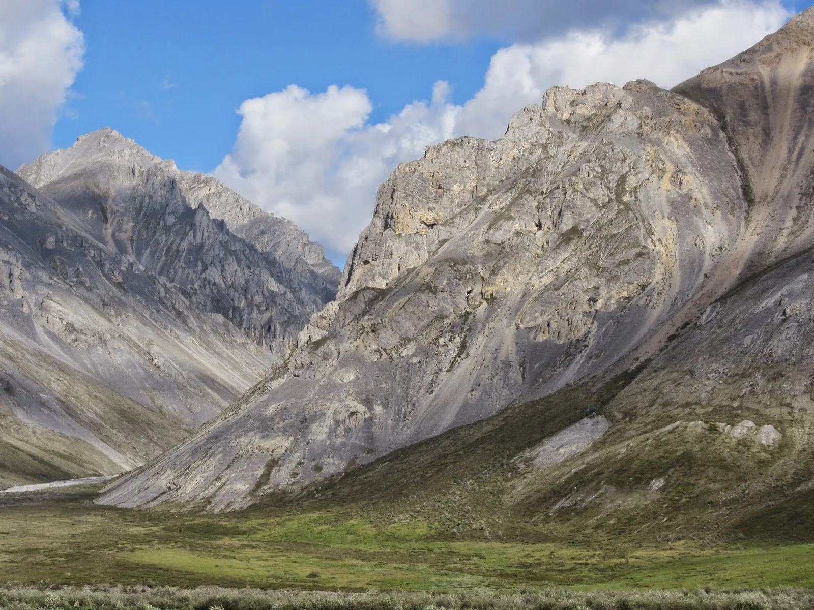
Following
this tributary towards the Kongakut River I ran into the exact opposite of paradise.
A spectacular mountain, with a steeply soaring slope reaching some 1000 meters
above the valley floor, was on my right. A much more reasonable hill on my left
promised a shortcut to the Kongakut. However, even if it was a comparatively a dwarf
it would demand a climb up from the easily travelled creek bottom onto tussock
country, as far as I could see.
I choose to
stay with the creek. This turned out to be a bad move. And foreboding what was
to come, in spades, further down the line.
The steep
giant to my right, it turned out, had dumped a huge load of it’s steep incline
into creek, an avalanche of rocks with sizes varying between that of cars and
tenement buildings. The easily travelled gravel bars were suddenly annihilated by
a maze of huge boulders through which an increasingly narrower and white water
foaming creek tortuously made its way.
So, no banks
left, and a malstroem of a creek to follow. The only choice was trying to find
slopes and boulders in and around and through this maze that were climbable
with a heavy pack and poles. I had some hairy moments in the hot sun before
exiting on the other side of this giant, kilometer-wide rockslide.


The parts
of the Kongakut River that I first encountered turned out to be spectacular. A
wide valley with a river bed consisting of 90 percent gravel bars, only 10
percent being water at this time of the year. This water flowed, braided,
through a number of channels. Watching over this were peaks that well matched the
one that had hatched the rockslide guarding the way to Paradise.
It all
reminded me of one of the most the spectacular areas in the Swedish mountains,
that around Rapaselet in Sarek National Park. Only there was more of it here.
More mountains and a longer stretch of beautiful river.

Life does not get much better for me than walking on sunshine along a wilderness river like this.
Later,
after having passed what could almost be called a ’gate’, the surrounding limestone
behemoths eased off and melted into more of rolling hill-like mountains. I ran
across my first wolf-tracks in the sand along the river here, and shortly after
not only the tracks of a grizzly, but also the unmistakable imprint of Homo
Vibramus.
These
hiking boot tracks I would encounter a couple more times during the next few
days, showing that somebody recently had more or less chosen the same path
along the Kongakut as I had. I never saw
this hiker or hikers.

Apart from these footprints there were no traces of man. No litter, no blackened fire rings, no rings of rocks signaling that there had been tent pegs weighted down. It was like walking through a dream of the original wilderness. The way I have always wanted it.

Apart from these footprints there were no traces of man. No litter, no blackened fire rings, no rings of rocks signaling that there had been tent pegs weighted down. It was like walking through a dream of the original wilderness. The way I have always wanted it.
The
Kongakut, meandering through this rocky and hilly landscape, established a
pattern of travel that I would use along rivers for the whole walk. On the
outer curves of the river bed the river usually carves more or less steep
rockfaces, that could be anything from one meter to 500 meters high. At this
outside of the bend in the river the current was at its fastest and deepest,
and thus the worst place to ford.
Along the inside
of the bends the water was running less deep, less fast and the banks were also
less severe or non existent. At low water like this they petered out into
gravel bars that could range for hundred of meters before the actual river
banks took over. So walking upstream in a river bed like this meant that you usually
crossed the river somewhere between two bends all the time, switching from one
gravel bar to another, avoiding the steep sides. The river being braided, this meant
numerous fords for each crossing of the river bed.


So I forded
20-30 times every day along the Kongakut, and for much of my hike along the
rivers through the ANWR. Only a couple of the fords along the Kongakut were
what I called ’80-percenters’. That is, I figured they had taxed my fording skills
to about 80 percent of my perceived capacity. This left reasonable margins so
far, even if my capacity probably only is 90 percent of what I perceive it to
be.
Hiking
through country like this, you can only dream of keeping your feet dry. Even
with rubber boots I would sooner or later have stepped into something too deep.
I knew this, and my chosen footwear for the soggy Scandinavian mountains turned
out to be ideal also in Brooks Range. I wore really thin nylon socks, 60
denier, and Salomon Tech Amphib mesh shoes.
My pants
were thin nylon Patagonia Houdinis, weighing only 100 grams, but wind-proof and
mosquito proof. After a knee deep ford it took less than 10 minutes for these
pants to become dry, a couple of centimeters at the bottom of each leg
excluded. The shoes and socks drained quickly but were of course more or less
permanently damp. However, this was a well-ventilated dampness that kept my
feet in excellent shape. Something that compared favorably to the sickly and
oxygen deprived hothouse dampness of wet, membraned hiking boots, something
that really tends to soften the skin of the feet bigtime.


Later in
the trip, when weather and water got colder I often wore neoprene socks, which
kept the cold at bay. When this was not enough, in snow and constant rain, I
donned pile socks for insulation and a pair of Rocky Goretex socks for
waterproofing. This was always enough to keep my feet pleasantly warm and dry
no matter the circumstances.
During this
entire hike along the spine of Brooks Range I did not develop even the tiniest
tendency towards blisters or cracks in the skin of my feet. After a couple of
days, however, I felt it would be nice with some support under the arches, so I
took a pair of Smartfeet Carbons, the lightest innersoles they have, from my
pack and used them in my shoes for the rest of my walk.
Basking in
the sunshine this evening, on the silt beach of the Kongakut, there was not
much to complain about. I had some pain in my left calf, some muscle tissue
having been ruptured or pulled. Not pleasant, but not slowing me down. I
suspected it would go away in a day or two. Also, the piezo igniter for my
Primus Eta Lite stove had lost its spark. Piezo igniters are comfortable, but
not very reliable in my experience. This one was a new replacement of one that
had broken during Coast2Coast Sweden only a month before. So I always carry
plenty of back up ignition for my stove. In fact, on this trip I carried a backup
stove for the first time in the shape of my trusty old Primus Micron, weighing
only a 100 grams.


The
following days the Kongakut got smaller and smaller. My pace had increased, I did a
couple of 18 and 21 kilometer days. Not impressive compared to Andrew Skurka
who averaged twice that through the Brooks, but pretty good for and elderly
fellow, from Sweden to booth. I was getting tuned into this particular terrain.
And having the time of my life.
I had been
snap-shooting with my Canon compact camera, but now figured it was time start
using the GoPro and making some film. What I found was that inspite having
brought three fully loaded batteries from Fairbanks, all three were now dead as
doornails and not nearly as useful. Also, my Neoair inflatable sleeping pad had
somehow begun to give me that sinking feeling. From my Nahanni trip a couple of
years ago I sort of suspected that it would also be impossible to find the hole
in the field and tape it or glue it. This turned out to be correct, so once
every middle-of- the-night I had to inflate the damned thing.


The weather
was still warm, even hot. Some nights it took until 2-3 o’clock before it was
cool enough to crawl into the sleeping bag. Signs of change in this weather
system showed on my last night by the Kongakut. This was the best place to
pitch my tent I had found so far, among some low willows a bit higher and away
from the river. I relaxed, sitting on my pad by the rushing river, at this
place running in one knee-deep channel some 15 meters across. Around me the
expanse of low hills gave way to distant more pinnacled mountains in the
distance. On the horizon to the west there was even a glacier shimmering
between some high and pointy guardian turrets. Camp Moor seemed a fitting name
to this home for the night.
The
following morning I misjudged my position slightly and started up the wrong arm
of the river towards its source. The source being a small lake in a tussocky
bowl not far from the next river on my agenda; the Sheenjek. No big deal, I
soon discovered my mistake, which forced me over a not too un-pleasantly steep
ridge with great views. It was sunny and
pleasantly warm and the whole expanse felt a bit like a dry version of Scotland.

I recovered my self-esteem as a navigator when I managed to avoid picking another wrong arm and stayed with the river I had come to like so much, the Kongakut, to it’s birthplace. Now the river was down to something I could jump across.
It rained a
bit when I passed the little lake where it all originated. It is positioned
right on top of the continental watershed. The Kongakut runs to the Arctic Ocean,
the Sheenjek empties in the Pacific. Travelling up over a long slope while the
rain petered out, I was now in the Sheenjek River watershed and could see the mountain citadell I knew was waiting on the far bank.

The
Sheenjek was not a known entity. The Garmin map had shown a valley that was
more of a lake in this area. How wide and fordable, or unfordable would it be? I
could not count on every river being the benevolent, braided bunch of creeks
that the Kongakut mostly had been. If I encountered a river several kilometers
wide and flowing fast, I would likely not be able to cross here.
In that
case I would have to follow the river upstream for as long as it would take to
find a safe ford. If I managed that I had made some alternate plans for
crossing the jumble of high peaks blocking my way west over a high pass.
Now, high
passes was also something that worried me. If you are not familiar with the
terrain it is difficult to grasp exactly how steep and difficult a pass shown on
a topographic or GPS map really is. A lot also depends on the footing if a
steep pass is passable or not. I had seen from Buck Nelsons film Alone Across
Alaska that he had climbed some seriously steep slopes.


My next
river, beyond the Sheenjek, was to be the East Fork of the Chandalar and the easiest access would be, not
to cross the jumble of glaciated peaks, but to go around the southern end of Double Mountain,
one of the few mountains with a name that I encountered, and then north-west,
along a nameless tributary to the East Fork. This passage into the next watershed seemed an easy route,
similar to the one I was just travelling from the Kongakut to the Sheenjek.
Much depended on the Sheenjek. Would it be fordable where I first encountered it or
not. What I glimpsed in the distance looked big, but I could not see how
braided it was nor to what extent it filled its river bed. Also, I find it
difficult to really judge the depth and speed of a river until I actually get
my feet wet and can feel the current against my legs.
I had a hunch that, once down by the Sheenjek, it would be a good idea to have a cup of
coffee and think things over.
Great trip and report! Give us more.
ReplyDeleteBill
I am trying to avoid the use of the words awesome and epic, and as a result I get a real sense of your thoughts and feelings as you wander through this remote wilderness where you are truly alone and dependent on your own skills for survival. By the way your photos in my view portray the reality of this untracked wilderness area
ReplyDeleteThanks Bill and Roger, much appreciate your kind words.
ReplyDeleteBy and by, as I check my notes and maps and write about my hike I begin the realize what an experience it was. At the time it was a bit more of "all in a days work" even if I certainly had time and presence of mind to marvel at beautiful views and the whole expanse if that great land.