For some background on the South Nahanni River and my planned trip, see earlier blog posts.
Almost everyone that paddles the Nahanni flies in to various points along the river. Now, a packraft is constructed for packing and my gut feeling was that I wanted to walk in to the Moose Ponds, the source of the Nahanni, from the nearest road. Do not ask me why. To feel worthy of the Nahanni perhaps, or just because I am generally pigheaded and want to do things my way.
Anyway, 40-50 kilometers cross country above timberline is something I normally would be able to do in two long days of hiking. The reality proved to be a lot rougher than I had expected. On the other hand, I was not unprepared. This is Canada, it is big, it is wild and you are on your own. That's why I came.
By Jörgen Johansson

The nearest road is a lone stretch of Yukon gravel going from the Ross River ferry to the border of the North West Territories (NWT) known as North Canol Rd. Some 200 kilometer up that road was my designated trail head. Simply a cross ón my map that seemed to offer a short stretch of hiking through the forest, a crossing of the MacMillan river and access to a pass leading across the watershed that forms the border between the Yukon and NWT, where the Moose Ponds are located.
On my map it looked like most of this distance could be hiked above timberline. I could get hold of no source that could confirm or deny this. People simply did not do what I was planning to do.
My friends Elaine and Terry, that drove me up the N Canol Rd, had to abandon me along the road due to a bunch of construction workers tearing up a bridge. So I started my trip walking on the road. The load was far from ultralight; about 22-25 kilos in a hastily bought MEC Alpinelite 85 pack, replacing my intended ULA Ohm which turned out to be way to small. Something that I should have checked more thoroughly.

The first night was spent along the road, with the Itsi Range as backdrop. A nice evening turned into a rainy night and morning. My trusty Gossamer Gear The One did prove to be the ideal tent for this trip, just as I had suspected.

The promised land did not look that promising when I took a 90 degree turn away from the road in a persistent drizzle. On the other side of the Macmillan River, you see a ridge sloping down to the right. Behind this ridge was the valley leading to the Moose Ponds. My plan was to gain elevation, get above timberline and then cross the ridge into the valley this side of the snow covered peak on the horizon.

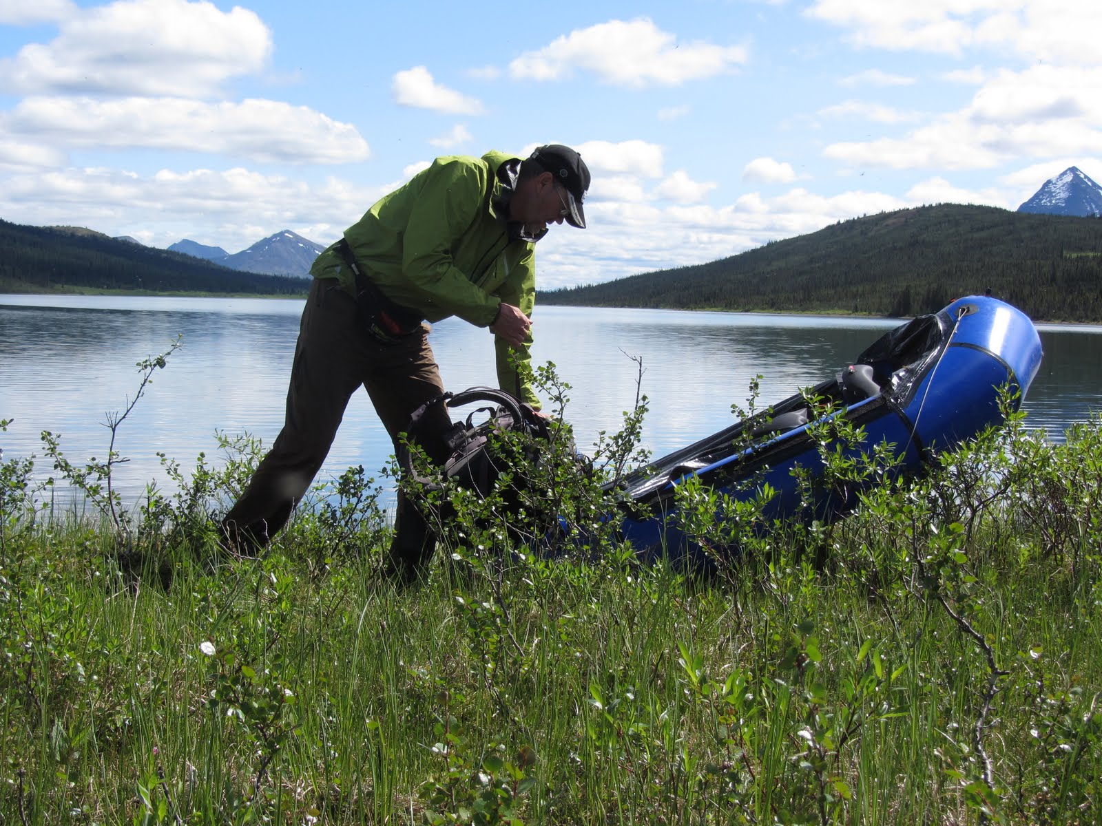
After a lunch under my tarp by the river, I inflated the packraft, donned my drysuit and PFD and strapped everything else to the foredeck. The crossing turned out to be quick and easy, however I was impressed by the force of the moving water. I had to paddle pretty vigourously while ferrying across the waterway. Before seeing the river I had entertained thoughts on swimming across it in drysuit and PDF, pushing my pack in front of me. One look convinced me that this river should be paddled instead.

My dreams of easy travel above timberline were pretty soon crushed by the brutal reality of the densely shrub-covered terrain. Reaching timberline proved to be something I attempted but gave up during that first afternoon. The last stretch of hillside below timberline was very steep and covered with creeping, bow shaped shrubs. I have battled with the likes of this in other areas and found it very taxing. So I decided that it was not worth the effort and choose to travel along the valley below timberline. The high shrubbery you see behind and around me turned out to become a faithful companion for almost the entire hike to the Moose Ponds.

It did not take me long to realise that any plans of reaching the Moose Ponds in two days had better be revised. I had already spent almost a full days hiking on the road before getting to my trailhead, which was not planned. I had brought food for 10 days, which meant two extra days rations, for the calculated time of the trip to my food cache at Rabbitkettle Lake, some 200 kilometers downstream from the Moose Ponds. This should be enough. If not I could handle a couple of days on small rations.
The first couple of days when I was beating my way through the bush, truly bush-whacking as the expressive expression is, it rained quite a bit. I had decided that I could leave my rain pants at home. The logic behind that being that I would only hike for two days out of three weeks; it also seemed likely that I could stay warm enough by hiking vigorously even without rain pants and if this did not work I could use my drysuit to avoid getting hypthermic.
It did not work. I was soon using my drysuit for hiking in order to stay warm enough in the chilly rain, as can be seen from the lunch stop at the photo above. The hood is a home-made addition of silnylon. The Cuben tarp I had brought served me extremely well as a shelter while eating in the rain. Hiking in the drysuit kept me nice and dry for almost a day. After that the shrubs won out, and the dry suit started leaking in a number of places from the waist down. Still, it kept me dry enough to stay warm.
A couple of small lakes nested nicely in the valley I was travelling. One lacked a name, the other is called Portrait Lake. Paddling these in the packraft was a blessing mentally. Inflating the raft and all the stuff that goes with a lake crossing takes time and maybe the 1-2 kilometer long lakes did not really justify the time spent, but it certainly was soothing beyond words to be able to rest my legs and relax from the ceaseless battle with the chlorophyllia for a brief interval.

After the initial rainy days the weather improved and the beauty of the country I was moving through was easier to appreciate. Sitting in the packraft really gives you a good view and makes it easier to appreciate the marvelous wilderness that I was crossing.

When the weather improved the mosquitos woke. This particular area was pretty waterlogged as well, with water half way to my knees as a rule. I had to wear my rain jacket to keep the blood suckers at bay, which was not ideal since I sweated a lot. But the wind shirt that I prefer to a rain jacket on occasions like these had also been left at home in order to save weight.

After two nights in the brush country I came down to Ross River, a long ways upstream from the ferry crossing in the First Nation town with the same name. Seeing the gravel bars and imagining the ease with which I should be able to walk along the river bed made me a happy man. And a warm (25 C in my tent at 10 pm) evening was nice after the wet and chilly crossing from N Canol Rd. I spread most of my gear on the gravel to dry it out and enjoyed the splendor surrounding me.

It rained heavily off and on during the night and this continued all morning. I was brought abruptly out of my tent in the morning by splashing sounds coming from the river. Some animal crossing. Friend or...? Sticking my head out with my bear spray at hand a saw a young bull moose in mid river, looking quizzically at me. After a couple of minutes of this he seemed to catch a whiff which brough home to him that I was a dangerous sort and he turned around and dissappeared on the other side of the river.

Hiking along the river did not turn out to be the cake walk I had imagined. The gravel bars did exist, but were more often on the other side of the river, it seemed. Low temperatures, incessant rain, a leaking battered drysuit and wet foliage had me combating hypotermia all morning. At one time I had to pitch the tarp and put on my Cocoon pullover to regain some body heat while gobbling my chocolate/raisins/hazelnuts.
Fortunately, while pitching my lunch tarp, the rain stopped. The sun began peeking through the clouds and the rest of the afternoon it was nice and warm. After lunch I easily waded the Ross River and took a compass bearing for the Moose Ponds, now being less than 5 kilometers distant.
Fortunately, while pitching my lunch tarp, the rain stopped. The sun began peeking through the clouds and the rest of the afternoon it was nice and warm. After lunch I easily waded the Ross River and took a compass bearing for the Moose Ponds, now being less than 5 kilometers distant.

The sun shone, but the shrubbery was consistently uncooperative to the very last. Behind my head is the perfect cone of Mt Wilson. It had been a landmark off and on for a couple of days. At its base I knew that I would find the Moose Ponds, where the Nahanni began. Seeing it made use of the compass unnecessary, it was just a matter of climbing through the foliage, leaving the Ross River watershed that ends up in the Pacific for the Nahanni watershed which ends up in the Arctic Ocean.

The shrubs grew smaller and the ground became wetter, sucking at my shoes in the sunshine and not making the walking much easier. And pretty soon there was enough water for me to inflate my raft and strap my pack onto it.

At last, I was floating. Paddling across the Moose Ponds in the late afternoon I was a happy man, even if I once got lost in a maze of reed and had to backtrack in order to find the outlet that rapidly became a sizable and fast-moving stream. The end of the labor pains was at hand, the Nahanni was born. From now on everything would be downhill....
Search this site for "Nahanni" to find further blog posts.
I hope that by labour pains, that a beautiful trip was born. Because, it looks like you passed through shrub hell to get to the Mosse Ponds.
ReplyDeleteA very nicely written introduction of an unexpected start to this trip, Jörgen. My tip when walking through shrubbery: Thinking of Monty Python =)
ReplyDeletePart II tomorrow, yes?
Dani,
ReplyDeleteBeing a man it is of course easy for me to say that I would not want to be without the labor pains :-)
But yes, a river trip was born, consisting of rain and shine, shadow and sunset and all the complexities that is what makes up living, I guess.
A good intro, promising an epic tale.
ReplyDeletePS: A small suggestion about the site: A trip report like this would really deserve to have bigger pictures. Twice the width should easily fit on modern screens, even on laptops.
Yes, picture size is a bit of a problem. 15 % of our readers have screens that are 1024 pixels wide or less, and we have a lot of stuff competing about the page width. We don't want to force sideways scrolling...
ReplyDeleteAnd we don't want the text rows to be to long, because that will mess up the readability of our long texts.
So, at the meantime, you will have to click to enlarge the pics. But next time we do a re-design, we will probably have a more pic-friendly layout.
Martin: http://goldengridsystem.com/ ;)
ReplyDeleteFantastic start to the trip report, keep it coming Jörgen! Looks like the Nahanni isn't going to give herself up easily.
ReplyDeleteWho was your Chief Trekking Pole Holder on this trip? ;)
A great beginning, and the photos clearly indicate the landscape you were passing through. Now on to part 2.
ReplyDeleteBig country. Your determination and adaptability comes across reading this. Looking forward to more.
ReplyDeleteJoe,
ReplyDeleteAs you know having a Chief Pole Holder (CPH) when top management is making far reaching and magnanimous decisions for the good of the minions is very important. Having to hold them yourself really sucks, but... a man's gotta do what a man's gotta do.
Martin,
Thanks. Of course adaption always comes easier when there is no choice :-)
Very good trip report! It is so nice to read about type2fun from others ;)
ReplyDeleteI had in Finland not these extreme conditions but I can still very good relate to this insights when looking for the first time on your plans made on the map and GE in reality.
And I would say inflating the packraft is always justified - I even do it for 30 seconds of paddling across a very small stream or the smallest lakes - the feeling of relief and relaxed look at the landscape is one of the best.
Great report! I like that you're so open in sharing the challenges you had.
ReplyDeleteThomas,
ReplyDeleteThank you. I always say that what you get out of something stands in direct proportion to what you put into it. And no outdoor experience has made such an impact on me, in a positive way, as the Nahanni trip.