Finally there. Landed and supporting my pack beside the plane, exchanging a few last words with Dirk Nickisch of Coyote Air.

The clouds were hanging low over Joe Creek, a place that is about as distant from everywhere as anyplace can be, even in Alaska. Some ten kilometers east the Yukon border would meet, going straight north up to the Arctic Ocean. Some 180 kilometers in the same direction I would find the nearest community, the roadless native village of Old Crow. Its counterpart in Alaska would be Arctic Village, also without access by road, some 200 kilometers southwest of Joe Creek. In fact the only road in this part of the world was where I was going, the Dalton Highway along the oil pipeline running straight through Alaska from the Arctic Ocean.
The Beaver plane that had flown me for a couple of hours from Coldfoot on the Dalton Highway to west had left about five minutes before. I had now emptied my entire pack. The gear and the food for 16 days were scattered among the tussocks. Everything was there, with one exception, as I had suspected. The GPS was missing.
There are times when I feel that I know what I am doing when travelling wild country on my own. This was not one of those times.
People that know me also know that I am not patient with little things that go wrong. I am much to prone to fly off the handle and use language my kids should never have been exposed to if I had been a responsible father. Luckily enough, I am much better at handling major fuck-ups. I was grateful for that now.
It was 2 pm and my belly told me that lunch was overdue. While heating water on my canister stove I sat-phoned Danielle at Coyote Air in Coldfoot. Before all of the Idahoan mashed potatoes had joined some sausage in my stomach we had decided that the GPS from my stash in Coldfoot should be put into the bear proof containers with food that they were transporting to the Marsh Fork of the Canning River. I would pick it up in two weeks.

As my grizzled countenance signals, I am not brought up with a GPS. I am not GPS dependent. Compass and map have always been my tools and the GPS a very handy addition that simplifies many things while hiking.
But this was the first time that I had planned my route almost entirely on a PC software and transferred waypoints to my handheld. Something that felt pretty nice in a country like Brooks Range. So this time I had relied way more on the GPS than ever before.
My plan was to walk across one of the last great wildernesses on earth; the Arctic National Wildlife Refuge. The ANWR is 80 000 square kilometers of protected land, sitting on top of Brooks Range, stretching from the Yukon border to the Dalton Highway, a k a "The Road", in the west. This makes the ANWR quite a bit bigger than Ireland and slightly smaller than Austria.
There are no roads, trails, bridges or people living permanently in the ANWR. Almost all mountains are nameless and unclimbed. Only the major rivers, flowing either south to the mighty Yukon River and on to the Pacific or north to the Arctic Ocean, have names. To quote Robert Service: "There's a land where the mountains are nameless, And the rivers all run God knows where".
This walk across the ANWR would be around 500 kilometers on the groundn and my plan indicated that I could do it in 25 days, if everything went without a hitch. I brought food for 30 days, 14 days of which would be shipped to my halfway cache. I did not expect everything to go without a hitch, but I had hoped to remain hitch-less slightly more than five minutes.

I only knew of five people who had travelled the entire lenght of the Brooks Range, from the Yukon border to the Bering Strait. As far as I knew most of them had walked about twice as far as I intended and then paddled the Noatak River to the sea. These people are in chronological order: Dick Griffith, Roman Dial, Buck Nelson, Andrew Skurka and Kristin Gates.
There are probably more people that have done this long hike and others that have walked the ANWR like I intended, but the fact remains: This is a good place to be if you like to be on your own. And I love to be on my own in wild country. This of course means that some people feel that therapy is long overdue for me. That does not worry me. I have my own therapy: Being on my own in wild country.
The trips of Buck Nelson and Andrew Skurka are the ones that are most well documented and those guys also helped me with various tips during my planning. Andrew has all his overnight camp coordinates on his web page (www.andrewskurka.com) and Buck also has a number of coordinates at his (www.bucktracks.com) plus his very inspiring film Alone Across Alaska that I have watched any number of times.
Their routes are fairly similar though and so would mine be, for a simple reason. To hike through this area as smoothly as possible you have to stay close to the continental divide between the Arctic Ocean and the Pacific. This is because that is where the rivers, no matter which direction they run, are at their smallest. And going for 500 kilometers through Alaska means you have to cross a lot of rivers. The smaller they are the easier it is, and less dangerous as well. I did not worry about bears, but I thought that river crossings would be the biggest danger. It turned out to be wrong, but that I did not know yet.
Fortunately neither Andrew nor Buck has chosen to give away all their secrets or show their routes in detail, more or less for the same reasons. To quote Andrew: "I didn’t want to take away from someone’s fun by making it easy to replicate my route".

I am very grateful for them holding their cards close to the chest and I hope it will be a long time before you can buy a detailed guide of every step that can be taken or should be taken when travelling the Brooks Range. In my mind there has to be some corners of our planet that are not smothered with words and crushed beneath well-meaning advice, allowing some of the misfits among us to explore and experience the unknown.
And now it seemed that without my GPS, the beginning of this trip would be a bit more of an exploration and experience than I had intended. No matter, this was not a mishap of the magnitude that could motivate me do abandon the whole walk or, being a cheap-skate, accept the cost of having the GPS flown out separately to me.
The first thing was to try and clear my mind of any regrets or doubts. I had my compass, I had my map and I had 40 years of experience using them in more or less wild country. That would be fine. Everything would be fine, that is what I had to tell myself. It would be an interesting experience.
However, I could not honestly say that I was used to maps running to the scale 1:250 000. In the Swedish mountains back home, the maps are usually 1:100 000, which gives quite a bit more detail without becoming unwieldy. There are maps of the Brooks Range with the scale 1:62 500, but now we are getting to the unwieldy bit. It is an awful lot of paper to carry around if you want them to cover a trip of 500 kilometers.
So I had compromised. I had planned my route on the GPS, loaded it down with tons of waypoints and then printed A4-size sheets of the area closest to the route in 250 K maps from the USGS, since my Garmin software did not allow printing. Some of the trickier passes I had printed from 62,5 K maps. Fortunately I had chosen to print all of this, not on ordinary paper, but on a very durable polymer paper called Nevertear. Something for which I now was truly grateful. And would be even more grateful.

The peaks bordering the valley around Joe Creek kept their distance, but they certainly were steep and sharp enough to impress. I am not used to limestone mountains and their exciting shapes, alternating between sharks teeth and turreted towers that could be taken from The Lord of the Rings. I would get used to these mountains during the month that followed, but never tired of them. Instead I fell in love with them.
I had seen films from Joe Creek and been amazed, but now I could see the real thing. The strangest occurence by far is a row of very steep and sharp pinnacles connected into pallisades in front of the much higher mountains. I did not encounter anything similar anywhere else along my route. These palisades seemed like some sort of first defense, intended to keep intruders away from the real mountains and their secrets.
I had no intention of challenging any of these fortifications. And I know what secrets lay behind the mountains. Nothing exciting really, just more mountains. My route lay due west along Joe Creek for a day or so. After an almost unnoticeable watershed I would gain access to a side creek that could to take me out of that drainage and let me pass over to the Kongakut river in another couple of days or so. In fact I would be hopping from one drainage to another all the way to The Road.
No gear, no GPS, nor maps nor anything else would be able to do this for me. There is only one way of walking 500 kilometers across any country, and that is by putting one foot in front of the other for as long as it takes.
So I was eager to get going. In fact, when starting out on a long trip like this I often have to temper my own feelings. One of which is awe. 500 kilometers of roadless wilderness! That is a long way, will I really be able to do this? What have I gotten myself into?
 However, my judgement tells me that it definetely is doable, particularly after having done similar distances before. But of course, you won't make it all this very afternoon. Because that is the other side of the pressure from a big task. If you should have any chance at all, you should get going as soon as possible and walk as fast as possible. This feeling also has to be tempered.
Walking so fast that you are half falling, taking no breaks and swearing every time the terrain forces you to slow down has never worked for me. So I find that rational behaviour works best. I focus on the facts. Besides, I'm on vacation, I want to have a good time and enjoy myself. I am not an athlete wanting to set speed records. I am not an adventurer looking for sponsors. I am not a masochist, wanting to punish myself. I am just a regular old guy on vacation and I have deliberately planned an enjoyable pace.
If I walk 17 kilometer every day according to the map, which of course will be more in the actual hilly and curvy real world, I will reach my food cache at the Marsh Fork of the Canning River in 14 days. That is 2 kilometer per hour for 8-9 hours of hiking. Should be doable. I know it is doable. And if not, I'll make it doable.
So I shouldered my re-packed pack with its 24 kilos or so, of which about 14 kilos were food and fuel, and tentatively pushed my lightweight mesh shoes into action among the alternating dry and soggy tussocks.
 Now, Alaska tussocks are famous, or infamous if you want, and we have our share of tussocks in the Scandinavian mountains as well, so this was not new and I knew it was something to be managed. And also that this was only the beginning. Might as well get used to it.
These tussocks were not the giant kind. In fact that would have been preferable. Later I would encounter giant tussocks, and they often give you the opportunity to walk around/between them which is easier than many other options. I found the giants easier to negotiate than the smaller ones that I usually ran into. Like now along Joe Creek.
The clouds were still hanging low, the air was muggy and there was not much wind. This made my progress sweaty and the mosquitous loved this, They were out in force to great me. No problem, that's the name of the game. I put on some repellent on my hands and donned a head net, this saviour of sanity in northern summers. My thin pants and wind shirt were bug proof.
I travelled some 7,5 kilometers in the three hours that remained of the day. Pretty good with a fully loaded pack and quite a bit of tussocks, I thought. Not much changes in elevation of course, I just followed the valley of Joe Creek. I just had to keep doing this for four weeks and I would see the pipline along Dalton Highway shining in the distance.
Around 7 pm I usually start looking for a campsite, even if there is daylight all night, as is the case north of the Arctic Circle in July. What I want for camp, minimally, is a flat spot big enough for my tent and water for drinking and cooking.
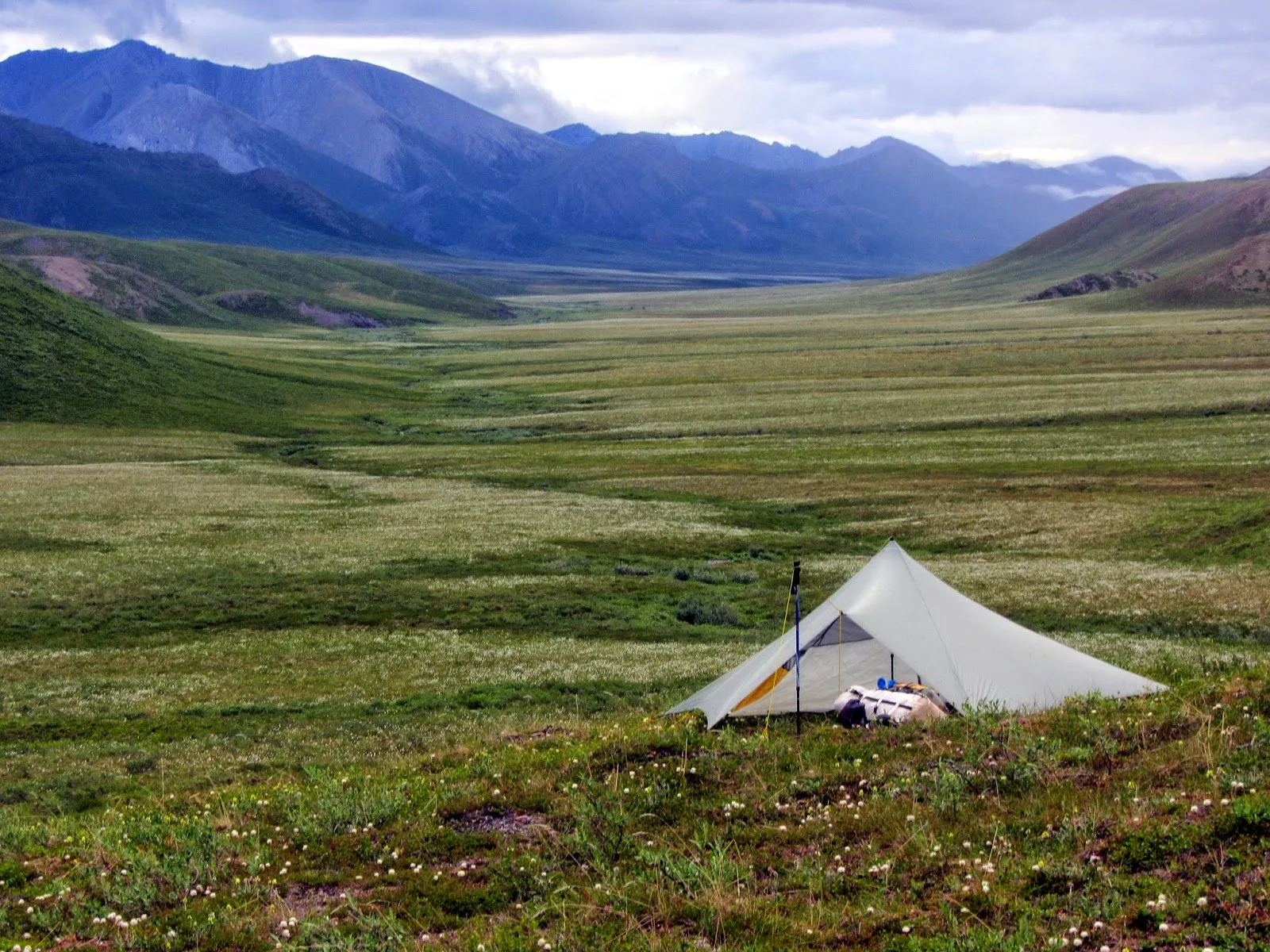
This minimum turned out to be hard to find this night. I eventually cooked and ate my standard evening noodles with some sausage down by the creek, among the tussocks and then retreated up-hill where the distance between the tussocks increased enough for me to pitch my Trailstar tent. I brought water for breakfast with me.
 The wind was coming from the east, just as I had, so I pitched my tent with the opening towards the opposite direction. As is not unusual, it did not take long for black clouds to appear in the west, the wind turned and a rain-storm rushed in. It lasted for 15-20 minutes and lashed at the tent, the rain unloading like a truckload of peas on my thin roof.
The Trailstar does not have an entrance zipper. It can be pitched very low in poor weather, but I had the regular pitch with a triangular funnel as entrance and exit, as can be seen from one of the photos above. This was the first serious test of my tent and I was ready for action in my rain gear, should some pegs come out from the wind blowing straight into the opening.
After a while I went out into the wind and the downpour to check the pegs, but I need not have worried, everything was ship-shape. After a while the rain and wind died down and I could relax. The rain did continue for most of the night, but that sound is one of my favourite lullabyes.
Before shutting myself into the sleeping bag for some shut-eye, I used the satellite phone to call my wife and tell her that everything was fine, with the slight exception of the GPS being in Coldfoot, of course. We decided that she would send my travel plans to Coyote Air. It would make it possible for them to deliver the GPS if they happened to have flights in the vicinity of my planned route.
Tomorrow would be the real beginning, were I would start learning what was on the map and what wasn't, which hues of green that signalled easy hiking and which didn't and all the other things that makes for a smooth ride. It was all up to me now. That is the way I like it. That is why I am here, miles upon miles from everyone and everything. Tomorrow. Today could have been worse.
Search for "Brooks Range" on this site to find further blog posts.
By Jörgen Johansson

The clouds were hanging low over Joe Creek, a place that is about as distant from everywhere as anyplace can be, even in Alaska. Some ten kilometers east the Yukon border would meet, going straight north up to the Arctic Ocean. Some 180 kilometers in the same direction I would find the nearest community, the roadless native village of Old Crow. Its counterpart in Alaska would be Arctic Village, also without access by road, some 200 kilometers southwest of Joe Creek. In fact the only road in this part of the world was where I was going, the Dalton Highway along the oil pipeline running straight through Alaska from the Arctic Ocean.
The Beaver plane that had flown me for a couple of hours from Coldfoot on the Dalton Highway to west had left about five minutes before. I had now emptied my entire pack. The gear and the food for 16 days were scattered among the tussocks. Everything was there, with one exception, as I had suspected. The GPS was missing.
There are times when I feel that I know what I am doing when travelling wild country on my own. This was not one of those times.
People that know me also know that I am not patient with little things that go wrong. I am much to prone to fly off the handle and use language my kids should never have been exposed to if I had been a responsible father. Luckily enough, I am much better at handling major fuck-ups. I was grateful for that now.
It was 2 pm and my belly told me that lunch was overdue. While heating water on my canister stove I sat-phoned Danielle at Coyote Air in Coldfoot. Before all of the Idahoan mashed potatoes had joined some sausage in my stomach we had decided that the GPS from my stash in Coldfoot should be put into the bear proof containers with food that they were transporting to the Marsh Fork of the Canning River. I would pick it up in two weeks.

As my grizzled countenance signals, I am not brought up with a GPS. I am not GPS dependent. Compass and map have always been my tools and the GPS a very handy addition that simplifies many things while hiking.
But this was the first time that I had planned my route almost entirely on a PC software and transferred waypoints to my handheld. Something that felt pretty nice in a country like Brooks Range. So this time I had relied way more on the GPS than ever before.
My plan was to walk across one of the last great wildernesses on earth; the Arctic National Wildlife Refuge. The ANWR is 80 000 square kilometers of protected land, sitting on top of Brooks Range, stretching from the Yukon border to the Dalton Highway, a k a "The Road", in the west. This makes the ANWR quite a bit bigger than Ireland and slightly smaller than Austria.
There are no roads, trails, bridges or people living permanently in the ANWR. Almost all mountains are nameless and unclimbed. Only the major rivers, flowing either south to the mighty Yukon River and on to the Pacific or north to the Arctic Ocean, have names. To quote Robert Service: "There's a land where the mountains are nameless, And the rivers all run God knows where".
This walk across the ANWR would be around 500 kilometers on the groundn and my plan indicated that I could do it in 25 days, if everything went without a hitch. I brought food for 30 days, 14 days of which would be shipped to my halfway cache. I did not expect everything to go without a hitch, but I had hoped to remain hitch-less slightly more than five minutes.

There are probably more people that have done this long hike and others that have walked the ANWR like I intended, but the fact remains: This is a good place to be if you like to be on your own. And I love to be on my own in wild country. This of course means that some people feel that therapy is long overdue for me. That does not worry me. I have my own therapy: Being on my own in wild country.
The trips of Buck Nelson and Andrew Skurka are the ones that are most well documented and those guys also helped me with various tips during my planning. Andrew has all his overnight camp coordinates on his web page (www.andrewskurka.com) and Buck also has a number of coordinates at his (www.bucktracks.com) plus his very inspiring film Alone Across Alaska that I have watched any number of times.
Their routes are fairly similar though and so would mine be, for a simple reason. To hike through this area as smoothly as possible you have to stay close to the continental divide between the Arctic Ocean and the Pacific. This is because that is where the rivers, no matter which direction they run, are at their smallest. And going for 500 kilometers through Alaska means you have to cross a lot of rivers. The smaller they are the easier it is, and less dangerous as well. I did not worry about bears, but I thought that river crossings would be the biggest danger. It turned out to be wrong, but that I did not know yet.
Fortunately neither Andrew nor Buck has chosen to give away all their secrets or show their routes in detail, more or less for the same reasons. To quote Andrew: "I didn’t want to take away from someone’s fun by making it easy to replicate my route".

I am very grateful for them holding their cards close to the chest and I hope it will be a long time before you can buy a detailed guide of every step that can be taken or should be taken when travelling the Brooks Range. In my mind there has to be some corners of our planet that are not smothered with words and crushed beneath well-meaning advice, allowing some of the misfits among us to explore and experience the unknown.
And now it seemed that without my GPS, the beginning of this trip would be a bit more of an exploration and experience than I had intended. No matter, this was not a mishap of the magnitude that could motivate me do abandon the whole walk or, being a cheap-skate, accept the cost of having the GPS flown out separately to me.
The first thing was to try and clear my mind of any regrets or doubts. I had my compass, I had my map and I had 40 years of experience using them in more or less wild country. That would be fine. Everything would be fine, that is what I had to tell myself. It would be an interesting experience.
However, I could not honestly say that I was used to maps running to the scale 1:250 000. In the Swedish mountains back home, the maps are usually 1:100 000, which gives quite a bit more detail without becoming unwieldy. There are maps of the Brooks Range with the scale 1:62 500, but now we are getting to the unwieldy bit. It is an awful lot of paper to carry around if you want them to cover a trip of 500 kilometers.
So I had compromised. I had planned my route on the GPS, loaded it down with tons of waypoints and then printed A4-size sheets of the area closest to the route in 250 K maps from the USGS, since my Garmin software did not allow printing. Some of the trickier passes I had printed from 62,5 K maps. Fortunately I had chosen to print all of this, not on ordinary paper, but on a very durable polymer paper called Nevertear. Something for which I now was truly grateful. And would be even more grateful.

The peaks bordering the valley around Joe Creek kept their distance, but they certainly were steep and sharp enough to impress. I am not used to limestone mountains and their exciting shapes, alternating between sharks teeth and turreted towers that could be taken from The Lord of the Rings. I would get used to these mountains during the month that followed, but never tired of them. Instead I fell in love with them.
I had seen films from Joe Creek and been amazed, but now I could see the real thing. The strangest occurence by far is a row of very steep and sharp pinnacles connected into pallisades in front of the much higher mountains. I did not encounter anything similar anywhere else along my route. These palisades seemed like some sort of first defense, intended to keep intruders away from the real mountains and their secrets.
I had no intention of challenging any of these fortifications. And I know what secrets lay behind the mountains. Nothing exciting really, just more mountains. My route lay due west along Joe Creek for a day or so. After an almost unnoticeable watershed I would gain access to a side creek that could to take me out of that drainage and let me pass over to the Kongakut river in another couple of days or so. In fact I would be hopping from one drainage to another all the way to The Road.
No gear, no GPS, nor maps nor anything else would be able to do this for me. There is only one way of walking 500 kilometers across any country, and that is by putting one foot in front of the other for as long as it takes.
So I was eager to get going. In fact, when starting out on a long trip like this I often have to temper my own feelings. One of which is awe. 500 kilometers of roadless wilderness! That is a long way, will I really be able to do this? What have I gotten myself into?

Walking so fast that you are half falling, taking no breaks and swearing every time the terrain forces you to slow down has never worked for me. So I find that rational behaviour works best. I focus on the facts. Besides, I'm on vacation, I want to have a good time and enjoy myself. I am not an athlete wanting to set speed records. I am not an adventurer looking for sponsors. I am not a masochist, wanting to punish myself. I am just a regular old guy on vacation and I have deliberately planned an enjoyable pace.
If I walk 17 kilometer every day according to the map, which of course will be more in the actual hilly and curvy real world, I will reach my food cache at the Marsh Fork of the Canning River in 14 days. That is 2 kilometer per hour for 8-9 hours of hiking. Should be doable. I know it is doable. And if not, I'll make it doable.
So I shouldered my re-packed pack with its 24 kilos or so, of which about 14 kilos were food and fuel, and tentatively pushed my lightweight mesh shoes into action among the alternating dry and soggy tussocks.

These tussocks were not the giant kind. In fact that would have been preferable. Later I would encounter giant tussocks, and they often give you the opportunity to walk around/between them which is easier than many other options. I found the giants easier to negotiate than the smaller ones that I usually ran into. Like now along Joe Creek.
The clouds were still hanging low, the air was muggy and there was not much wind. This made my progress sweaty and the mosquitous loved this, They were out in force to great me. No problem, that's the name of the game. I put on some repellent on my hands and donned a head net, this saviour of sanity in northern summers. My thin pants and wind shirt were bug proof.
I travelled some 7,5 kilometers in the three hours that remained of the day. Pretty good with a fully loaded pack and quite a bit of tussocks, I thought. Not much changes in elevation of course, I just followed the valley of Joe Creek. I just had to keep doing this for four weeks and I would see the pipline along Dalton Highway shining in the distance.
Around 7 pm I usually start looking for a campsite, even if there is daylight all night, as is the case north of the Arctic Circle in July. What I want for camp, minimally, is a flat spot big enough for my tent and water for drinking and cooking.
This minimum turned out to be hard to find this night. I eventually cooked and ate my standard evening noodles with some sausage down by the creek, among the tussocks and then retreated up-hill where the distance between the tussocks increased enough for me to pitch my Trailstar tent. I brought water for breakfast with me.

The Trailstar does not have an entrance zipper. It can be pitched very low in poor weather, but I had the regular pitch with a triangular funnel as entrance and exit, as can be seen from one of the photos above. This was the first serious test of my tent and I was ready for action in my rain gear, should some pegs come out from the wind blowing straight into the opening.
After a while I went out into the wind and the downpour to check the pegs, but I need not have worried, everything was ship-shape. After a while the rain and wind died down and I could relax. The rain did continue for most of the night, but that sound is one of my favourite lullabyes.
Before shutting myself into the sleeping bag for some shut-eye, I used the satellite phone to call my wife and tell her that everything was fine, with the slight exception of the GPS being in Coldfoot, of course. We decided that she would send my travel plans to Coyote Air. It would make it possible for them to deliver the GPS if they happened to have flights in the vicinity of my planned route.
Tomorrow would be the real beginning, were I would start learning what was on the map and what wasn't, which hues of green that signalled easy hiking and which didn't and all the other things that makes for a smooth ride. It was all up to me now. That is the way I like it. That is why I am here, miles upon miles from everyone and everything. Tomorrow. Today could have been worse.
Search for "Brooks Range" on this site to find further blog posts.
Excellent stuff, I've been looking forward to this trip report since you returned, Jörgen!
ReplyDeleteThanks, Joe. So have I ;-)
ReplyDeleteVery remote wilderness. Apex predators and big mountains - amazing destination Jörgen. Excellent start, and as Joe says been looking forward to reading this.
ReplyDeleteAwesome account of your adventure, Jorgen. I look forward to the next part!
ReplyDeleteThanks, Buck. And thank you for your help and even more, inspiration. And by the way, the next part is already on line ;-)
ReplyDeleteExcellent stuff, I suspect that my reaction to a lost gps would mirror yours and yes then I would move on. Your thought provoking sentences at the end of this article highlight some of the challenges that you faced. Off to read part 2 now.
ReplyDeleteThanks Roger. Yes, often there is not much choice but to keep on moving.
ReplyDeleteNice
ReplyDelete